Campok geodata
Campok (East Java) is a seat of a fourth-order administrative division; located in Indonesia in Asia/Jakarta (GMT+7) time zone. In our database, there are 407 cities with bigger population. Compared to other cities in Indonesia, 67% of cities are located further ↑North; 52.6% of cities are located further →East and 52.3% of cities have higher elevation than Campok. Note1


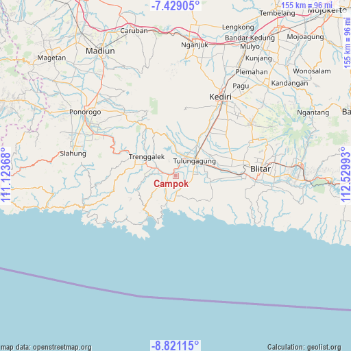
Campok GPS coordinates[2]
8° 7' 32.52" South, 111° 49' 36.48" East
| Map corner | latitude | longitude |
|---|---|---|
| Upper-left | -7.42905°, | 111.12368° |
| Center: | -8.1257°, | 111.8268° |
| Lower-right: | -8.82115°, | 112.52993° |
| Map W x H: | 154.8×154.8 km | = 96.2×96.2mi |
| max Lat: | 5.88969° ⇑67% North |
| Campok: | -8.1257° |
| min Lat: | ⇓33% South -10.934° |
| min Long | Campok | max Long |
| 95.1345° | 111.8268° | 140.9419° |
| W 47.4%⇐ | ⇒52.6% E |
Elevation
Elevation of Campok is 94 m = 308 ft, and this is 135.7 m = 445 ft below average elevation for this country.
| Max E: |
3185 m = 10449 ft | 52.3% |
| Avg. | 229.7 m = 754 ft | |
| Campok | 94 m = 308 ft | |
Min E: |
-1 m = -3 ft | 47.7% |
See also: Indonesia elevation on elevation.city.
Geographical zone
Campok is located in South Torrid zone (between Equator and Tropic of Capricorn). Distance of Equator is 903.5 km =561.4 mi to North.| Distance of | km | miles | from Campok |
|---|---|---|---|
| Equator | 903.5 | 561.4 | to North |
| Tropic Capricorn | 1702.4 | 1057.8 | to South |
| Antarctic Circle | 6497.7 | 4037.5 | to South |
| South Pole | 9103.6 | 5656.7 | to South |


Nearby cities:
15 places around Campok: (largest is in red/bold)
• Bangunmulyo
3.1 km =1.9 mi,  163°
163°
• Dungkul
1.8 km =1.1 mi,  92°
92°
• Genengan Kulon
1.1 km =0.7 mi,  115°
115°
• Jajar
2 km =1.2 mi,  335°
335°
• Kasreman Wetan
2.7 km =1.7 mi,  145°
145°
• Kendal
2.9 km =1.8 mi,  53°
53°
• Nglengkong
2.2 km =1.4 mi,  23°
23°
• Ngrance
2.2 km =1.4 mi,  130°
130°
• Pakis
2.7 km =1.7 mi,  296°
296°
• Pandean
2.2 km =1.4 mi,  287°
287°
• Payaman
2.2 km =1.4 mi,  275°
275°
• Pecuk
2.2 km =1.4 mi,  168°
168°
• Sanan
1.5 km =0.9 mi, 149°
• Suwaluh
2.1 km =1.3 mi,  225°
225°
• Tertek
1.4 km =0.9 mi, 285°
Sources, notices
• [Note1] Compared only with cities in Indonesia existing in our database
• [Src1] Map data: © OpenStreetMap contributors (CC-BY-SA)
• [Src2] Other city data from geonames.org with taken over terms of usage.
• [Src3] Geographical zone / Annual Mean Temperature by Robert A. Rohde @ Wikipedia
