Kasreman Wetan geodata
Kasreman Wetan (East Java) is a seat of a fourth-order administrative division; located in Indonesia in Asia/Jakarta (GMT+7) time zone. In our database, there are 407 cities with bigger population. Compared to other cities in Indonesia, 68.3% of cities are located further ↑North; 52.4% of cities are located further →East and 54.3% of cities have higher elevation than Kasreman Wetan. Note1


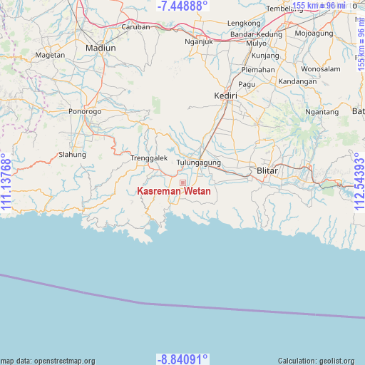
Kasreman Wetan GPS coordinates[2]
8° 8' 43.8" South, 111° 50' 26.88" East
| Map corner | latitude | longitude |
|---|---|---|
| Upper-left | -7.44888°, | 111.13768° |
| Center: | -8.1455°, | 111.8408° |
| Lower-right: | -8.84091°, | 112.54393° |
| Map W x H: | 154.8×154.8 km | = 96.2×96.2mi |
| max Lat: | 5.88969° ⇑68.3% North |
| Kasreman Wetan: | -8.1455° |
| min Lat: | ⇓31.7% South -10.934° |
| min Long | Kasreman Wetan | max Long |
| 95.1345° | 111.8408° | 140.9419° |
| W 47.6%⇐ | ⇒52.4% E |
Elevation
Elevation of Kasreman Wetan is 88 m = 289 ft, and this is 141.7 m = 465 ft below average elevation for this country.
| Max E: |
3185 m = 10449 ft | 54.3% |
| Avg. | 229.7 m = 754 ft | |
| Kasreman Wetan | 88 m = 289 ft | |
Min E: |
-1 m = -3 ft | 45.7% |
See also: Indonesia elevation on elevation.city.
Geographical zone
Kasreman Wetan is located in South Torrid zone (between Equator and Tropic of Capricorn). Distance of Equator is 905.7 km =562.8 mi to North.| Distance of | km | miles | from Kasreman Wetan |
|---|---|---|---|
| Equator | 905.7 | 562.8 | to North |
| Tropic Capricorn | 1700.2 | 1056.5 | to South |
| Antarctic Circle | 6495.5 | 4036.1 | to South |
| South Pole | 9101.4 | 5655.3 | to South |


Nearby cities:
15 places around Kasreman Wetan: (largest is in red/bold)
• Bangunmulyo
1.1 km =0.7 mi,  219°
219°
• Bangus Kulon
2.3 km =1.4 mi,  83°
83°
• Campok
2.7 km =1.7 mi,  325°
325°
• Campurdarat
2.6 km =1.6 mi,  147°
147°
• Campurjanggang
2.6 km =1.6 mi,  133°
133°
• Dungkul
2.1 km =1.3 mi,  7°
7°
• Genengan Kulon
1.8 km =1.1 mi,  343°
343°
• Gesikan
3.2 km =2 mi,  53°
53°
• Krenggan
2.3 km =1.4 mi,  188°
188°
• Ngrance
0.8 km =0.5 mi, 8°
• Pakel
1.9 km =1.2 mi,  238°
238°
• Pecuk
1.1 km =0.7 mi,  270°
270°
• Sanan
1.2 km =0.7 mi,  318°
318°
• Sodo
2.8 km =1.7 mi, 216°
• Suwaluh
3.1 km =1.9 mi,  283°
283°
Sources, notices
• [Note1] Compared only with cities in Indonesia existing in our database
• [Src1] Map data: © OpenStreetMap contributors (CC-BY-SA)
• [Src2] Other city data from geonames.org with taken over terms of usage.
• [Src3] Geographical zone / Annual Mean Temperature by Robert A. Rohde @ Wikipedia
