Besole geodata
Besole (East Java) is a seat of a fourth-order administrative division; located in Indonesia in Asia/Jakarta (GMT+7) time zone. In our database, there are 407 cities with bigger population. Compared to other cities in Indonesia, 73.1% of cities are located further ↑North; 52.7% of cities are located further →East and 53% of cities have higher elevation than Besole. Note1


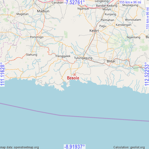
Besole GPS coordinates[2]
8° 13' 26.76" South, 111° 49' 9.84" East
| Map corner | latitude | longitude |
|---|---|---|
| Upper-left | -7.52761°, | 111.11628° |
| Center: | -8.2241°, | 111.8194° |
| Lower-right: | -8.91937°, | 112.52253° |
| Map W x H: | 154.7×154.8 km | = 96.1×96.2mi |
| max Lat: | 5.88969° ⇑73.1% North |
| Besole: | -8.2241° |
| min Lat: | ⇓26.9% South -10.934° |
| min Long | Besole | max Long |
| 95.1345° | 111.8194° | 140.9419° |
| W 47.3%⇐ | ⇒52.7% E |
Elevation
Elevation of Besole is 92 m = 302 ft, and this is 137.7 m = 452 ft below average elevation for this country.
| Max E: |
3185 m = 10449 ft | 53% |
| Avg. | 229.7 m = 754 ft | |
| Besole | 92 m = 302 ft | |
Min E: |
-1 m = -3 ft | 47% |
See also: Indonesia elevation on elevation.city.
Geographical zone
Besole is located in South Torrid zone (between Equator and Tropic of Capricorn). Distance of Equator is 914.4 km =568.2 mi to North.| Distance of | km | miles | from Besole |
|---|---|---|---|
| Equator | 914.4 | 568.2 | to North |
| Tropic Capricorn | 1691.5 | 1051 | to South |
| Antarctic Circle | 6486.7 | 4030.6 | to South |
| South Pole | 9092.6 | 5649.9 | to South |


Nearby cities:
15 places around Besole: (largest is in red/bold)
• Besuki Dua
4.1 km =2.5 mi,  283°
283°
• Besuki Satu
5.1 km =3.2 mi,  289°
289°
• Cerme Kidul
5.4 km =3.4 mi,  26°
26°
• Gebang
5.3 km =3.3 mi,  357°
357°
• Gedangan
3 km =1.9 mi,  16°
16°
• Gendingan
5.9 km =3.7 mi, 19°
• Keboireng
5.7 km =3.5 mi, 283°
• Kundung
5.8 km =3.6 mi,  306°
306°
• Ngentrong
1.8 km =1.1 mi, 23°
• Ngepoh Kidul
5.5 km =3.4 mi,  72°
72°
• Ngrejo
3.7 km =2.3 mi,  97°
97°
• Sawo
2.9 km =1.8 mi, 32°
• Sidomulyo
5.3 km =3.3 mi,  347°
347°
• Turus
5.4 km =3.4 mi, 290°
• Welahan
4.2 km =2.6 mi, 292°
Sources, notices
• [Note1] Compared only with cities in Indonesia existing in our database
• [Src1] Map data: © OpenStreetMap contributors (CC-BY-SA)
• [Src2] Other city data from geonames.org with taken over terms of usage.
• [Src3] Geographical zone / Annual Mean Temperature by Robert A. Rohde @ Wikipedia
