Sawo geodata
Sawo (East Java) is a seat of a fourth-order administrative division; located in Indonesia in Asia/Jakarta (GMT+7) time zone. In our database, there are 407 cities with bigger population. Compared to other cities in Indonesia, 71.7% of cities are located further ↑North; 52.5% of cities are located further →East and 52% of cities have higher elevation than Sawo. Note1


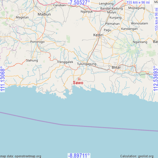
Sawo GPS coordinates[2]
8° 12' 6.48" South, 111° 50' 1.68" East
| Map corner | latitude | longitude |
|---|---|---|
| Upper-left | -7.50527°, | 111.13068° |
| Center: | -8.2018°, | 111.8338° |
| Lower-right: | -8.89711°, | 112.53693° |
| Map W x H: | 154.8×154.8 km | = 96.2×96.2mi |
| max Lat: | 5.88969° ⇑71.7% North |
| Sawo: | -8.2018° |
| min Lat: | ⇓28.3% South -10.934° |
| min Long | Sawo | max Long |
| 95.1345° | 111.8338° | 140.9419° |
| W 47.5%⇐ | ⇒52.5% E |
Elevation
Elevation of Sawo is 95 m = 312 ft, and this is 134.7 m = 442 ft below average elevation for this country.
| Max E: |
3185 m = 10449 ft | 52% |
| Avg. | 229.7 m = 754 ft | |
| Sawo | 95 m = 312 ft | |
Min E: |
-1 m = -3 ft | 48% |
See also: Indonesia elevation on elevation.city.
Geographical zone
Sawo is located in South Torrid zone (between Equator and Tropic of Capricorn). Distance of Equator is 912 km =566.7 mi to North.| Distance of | km | miles | from Sawo |
|---|---|---|---|
| Equator | 912 | 566.7 | to North |
| Tropic Capricorn | 1694 | 1052.6 | to South |
| Antarctic Circle | 6489.2 | 4032.2 | to South |
| South Pole | 9095.1 | 5651.4 | to South |


Nearby cities:
15 places around Sawo: (largest is in red/bold)
• Besole
2.9 km =1.8 mi,  212°
212°
• Campurdarat
4.6 km =2.9 mi,  28°
28°
• Cerme Kidul
2.5 km =1.6 mi,  19°
19°
• Gebang
3.4 km =2.1 mi,  326°
326°
• Gedangan
0.8 km =0.5 mi,  295°
295°
• Gendingan
3.1 km =1.9 mi,  7°
7°
• Krenggan
4 km =2.5 mi, 6°
• Ngayem
4.4 km =2.7 mi,  80°
80°
• Ngentrong
1.2 km =0.7 mi,  226°
226°
• Ngepoh Kidul
3.7 km =2.3 mi,  102°
102°
• Ngrejo
3.6 km =2.2 mi,  145°
145°
• Sidomulyo
3.8 km =2.4 mi,  314°
314°
• Sodo
4.1 km =2.5 mi,  346°
346°
• Sukoanyar
4.6 km =2.9 mi,  319°
319°
• Tanggunggunung
5 km =3.1 mi,  111°
111°
Sources, notices
• [Note1] Compared only with cities in Indonesia existing in our database
• [Src1] Map data: © OpenStreetMap contributors (CC-BY-SA)
• [Src2] Other city data from geonames.org with taken over terms of usage.
• [Src3] Geographical zone / Annual Mean Temperature by Robert A. Rohde @ Wikipedia
