Ngrendeng geodata
Ngrendeng (East Java) is a seat of a fourth-order administrative division; located in Indonesia in Asia/Jakarta (GMT+7) time zone. In our database, there are 407 cities with bigger population. Compared to other cities in Indonesia, 64.1% of cities are located further ↑North; 52.2% of cities are located further →East and 50% of cities have lower elevation than Ngrendeng. Note1


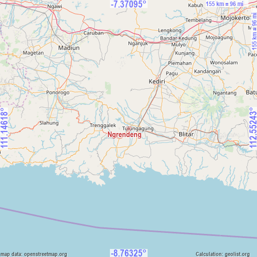
Ngrendeng GPS coordinates[2]
8° 4' 3.72" South, 111° 50' 57.48" East
| Map corner | latitude | longitude |
|---|---|---|
| Upper-left | -7.37095°, | 111.14618° |
| Center: | -8.0677°, | 111.8493° |
| Lower-right: | -8.76325°, | 112.55243° |
| Map W x H: | 154.8×154.8 km | = 96.2×96.2mi |
| max Lat: | 5.88969° ⇑64.1% North |
| Ngrendeng: | -8.0677° |
| min Lat: | ⇓35.9% South -10.934° |
| min Long | Ngrendeng | max Long |
| 95.1345° | 111.8493° | 140.9419° |
| W 47.8%⇐ | ⇒52.2% E |
Elevation
Elevation of Ngrendeng is 102 m = 335 ft, and this is 127.7 m = 419 ft below average elevation for this country.
| Max E: |
3185 m = 10449 ft | 50% |
| Avg. | 229.7 m = 754 ft | |
| Ngrendeng | 102 m = 335 ft | |
Min E: |
-1 m = -3 ft | 50% |
See also: Indonesia elevation on elevation.city.
Geographical zone
Ngrendeng is located in South Torrid zone (between Equator and Tropic of Capricorn). Distance of Equator is 897 km =557.4 mi to North.| Distance of | km | miles | from Ngrendeng |
|---|---|---|---|
| Equator | 897 | 557.4 | to North |
| Tropic Capricorn | 1708.9 | 1061.9 | to South |
| Antarctic Circle | 6504.1 | 4041.5 | to South |
| South Pole | 9110 | 5660.7 | to South |


Nearby cities:
15 places around Ngrendeng: (largest is in red/bold)
• Bebekan
2.7 km =1.7 mi,  73°
73°
• Bendo
2 km =1.2 mi,  108°
108°
• Bendungan
0.5 km =0.3 mi,  229°
229°
• Blendis
2.8 km =1.7 mi,  287°
287°
• Bolorejo
2.2 km =1.4 mi,  42°
42°
• Dami
2.2 km =1.4 mi,  129°
129°
• Gondang
0.7 km =0.4 mi,  200°
200°
• Jarakan
0.9 km =0.6 mi,  19°
19°
• Kalangbret
2.4 km =1.5 mi,  46°
46°
• Karangsari
2.8 km =1.7 mi,  261°
261°
• Kiping
1.2 km =0.7 mi,  180°
180°
• Kleben
2.1 km =1.3 mi,  332°
332°
• Mojasari
2.8 km =1.7 mi,  30°
30°
• Sepatan
2.2 km =1.4 mi, 182°
• Wonokromo
1.2 km =0.7 mi,  0°
0°
Sources, notices
• [Note1] Compared only with cities in Indonesia existing in our database
• [Src1] Map data: © OpenStreetMap contributors (CC-BY-SA)
• [Src2] Other city data from geonames.org with taken over terms of usage.
• [Src3] Geographical zone / Annual Mean Temperature by Robert A. Rohde @ Wikipedia
