Gondosuli geodata
Gondosuli (East Java) is a seat of a fourth-order administrative division; located in Indonesia in Asia/Jakarta (GMT+7) time zone. In our database, there are 407 cities with bigger population. Compared to other cities in Indonesia, 65.4% of cities are located further ↑North; 52.1% of cities are located further →East and 53.7% of cities have higher elevation than Gondosuli. Note1


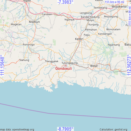
Gondosuli GPS coordinates[2]
8° 5' 42" South, 111° 51' 34.56" East
| Map corner | latitude | longitude |
|---|---|---|
| Upper-left | -7.3983°, | 111.15648° |
| Center: | -8.095°, | 111.8596° |
| Lower-right: | -8.7905°, | 112.56273° |
| Map W x H: | 154.8×154.8 km | = 96.2×96.2mi |
| max Lat: | 5.88969° ⇑65.4% North |
| Gondosuli: | -8.095° |
| min Lat: | ⇓34.6% South -10.934° |
| min Long | Gondosuli | max Long |
| 95.1345° | 111.8596° | 140.9419° |
| W 47.9%⇐ | ⇒52.1% E |
Elevation
Elevation of Gondosuli is 90 m = 295 ft, and this is 139.7 m = 458 ft below average elevation for this country.
| Max E: |
3185 m = 10449 ft | 53.7% |
| Avg. | 229.7 m = 754 ft | |
| Gondosuli | 90 m = 295 ft | |
Min E: |
-1 m = -3 ft | 46.3% |
See also: Indonesia elevation on elevation.city.
Geographical zone
Gondosuli is located in South Torrid zone (between Equator and Tropic of Capricorn). Distance of Equator is 900.1 km =559.3 mi to North.| Distance of | km | miles | from Gondosuli |
|---|---|---|---|
| Equator | 900.1 | 559.3 | to North |
| Tropic Capricorn | 1705.8 | 1059.9 | to South |
| Antarctic Circle | 6501.1 | 4039.6 | to South |
| South Pole | 9107 | 5658.8 | to South |


Nearby cities:
15 places around Gondosuli: (largest is in red/bold)
• Bendo
2.5 km =1.6 mi,  18°
18°
• Bendungan
3.1 km =1.9 mi,  330°
330°
• Dami
1.7 km =1.1 mi, 20°
• Dukuh
1 km =0.6 mi,  279°
279°
• Gajah
0.5 km =0.3 mi,  297°
297°
• Gempolan Wetan
2.2 km =1.4 mi,  184°
184°
• Gondang
2.8 km =1.7 mi, 330°
• Kendal
2.1 km =1.3 mi,  216°
216°
• Kiping
2.1 km =1.3 mi, 327°
• Ngipik
2.1 km =1.3 mi,  117°
117°
• Nglengkong
3.1 km =1.9 mi,  242°
242°
• Ngrendeng
3.2 km =2 mi,  339°
339°
• Pacet
3 km =1.9 mi,  53°
53°
• Sepatan
1.5 km =0.9 mi,  305°
305°
• Temenggungan
1.2 km =0.7 mi,  146°
146°
Sources, notices
• [Note1] Compared only with cities in Indonesia existing in our database
• [Src1] Map data: © OpenStreetMap contributors (CC-BY-SA)
• [Src2] Other city data from geonames.org with taken over terms of usage.
• [Src3] Geographical zone / Annual Mean Temperature by Robert A. Rohde @ Wikipedia
