Baruklinting Dua geodata
Baruklinting Dua (East Java) is a seat of a fourth-order administrative division; located in Indonesia in Asia/Jakarta (GMT+7) time zone. In our database, there are 407 cities with bigger population. Compared to other cities in Indonesia, 65.4% of cities are located further ↑North; 52.6% of cities are located further →East and 50.3% of cities have higher elevation than Baruklinting Dua. Note1


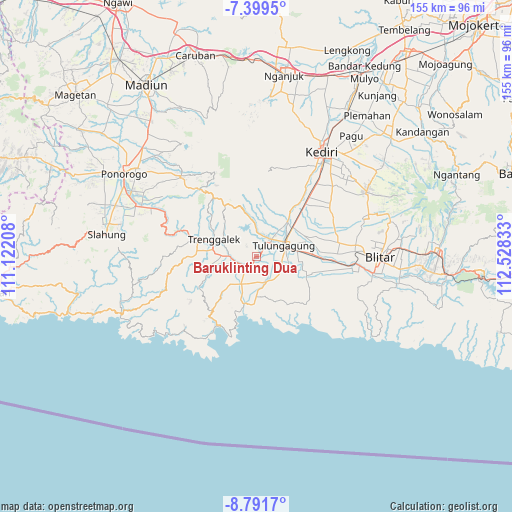
Baruklinting Dua GPS coordinates[2]
8° 5' 46.32" South, 111° 49' 30.72" East
| Map corner | latitude | longitude |
|---|---|---|
| Upper-left | -7.3995°, | 111.12208° |
| Center: | -8.0962°, | 111.8252° |
| Lower-right: | -8.7917°, | 112.52833° |
| Map W x H: | 154.8×154.8 km | = 96.2×96.2mi |
| max Lat: | 5.88969° ⇑65.4% North |
| Baruklinting Dua: | -8.0962° |
| min Lat: | ⇓34.6% South -10.934° |
| min Long | Baruklinting Du | max Long |
| 95.1345° | 111.8252° | 140.9419° |
| W 47.4%⇐ | ⇒52.6% E |
Elevation
Elevation of Baruklinting Dua is 101 m = 331 ft, and this is 128.7 m = 422 ft below average elevation for this country.
| Max E: |
3185 m = 10449 ft | 50.3% |
| Avg. | 229.7 m = 754 ft | |
| Baruklinting Dua | 101 m = 331 ft | |
Min E: |
-1 m = -3 ft | 49.7% |
See also: Indonesia elevation on elevation.city.
Geographical zone
Baruklinting Dua is located in South Torrid zone (between Equator and Tropic of Capricorn). Distance of Equator is 900.2 km =559.4 mi to North.| Distance of | km | miles | from Baruklinting Dua |
|---|---|---|---|
| Equator | 900.2 | 559.4 | to North |
| Tropic Capricorn | 1705.7 | 1059.9 | to South |
| Antarctic Circle | 6501 | 4039.5 | to South |
| South Pole | 9106.8 | 5658.7 | to South |


Nearby cities:
15 places around Baruklinting Dua: (largest is in red/bold)
• Campok
3.3 km =2.1 mi,  176°
176°
• Dukuh
2.8 km =1.7 mi,  83°
83°
• Gador
1.7 km =1.1 mi,  287°
287°
• Jajar
1.6 km =1 mi,  204°
204°
• Karangsari
2.8 km =1.7 mi,  358°
358°
• Karangtengah
1.1 km =0.7 mi,  348°
348°
• Kendal
3 km =1.9 mi,  120°
120°
• Kiping
3.3 km =2.1 mi,  53°
53°
• Nglengkong
1.7 km =1.1 mi,  140°
140°
• Pakis
3.1 km =1.9 mi,  226°
226°
• Pandean
3.2 km =2 mi,  216°
216°
• Sendangkemulian
1 km =0.6 mi,  263°
263°
• Sepatan
2.7 km =1.7 mi,  68°
68°
• Sidem
2.4 km =1.5 mi,  320°
320°
• Tertek
3.1 km =1.9 mi, 201°
Sources, notices
• [Note1] Compared only with cities in Indonesia existing in our database
• [Src1] Map data: © OpenStreetMap contributors (CC-BY-SA)
• [Src2] Other city data from geonames.org with taken over terms of usage.
• [Src3] Geographical zone / Annual Mean Temperature by Robert A. Rohde @ Wikipedia
