Pudi geodata
Pudi (East Nusa Tenggara) is a seat of a fourth-order administrative division; located in Indonesia in Asia/Makassar (GMT+8) time zone. In our database, there are 407 cities with bigger population. Compared to other cities in Indonesia, 99.1% of cities are located further ↑North; 87.4% of cities are located further ←West and 58.5% of cities have lower elevation than Pudi. Note1


Pudi GPS coordinates[2]
10° 35' 20.76" South, 121° 45' 27" East
| Map corner | latitude | longitude |
|---|---|---|
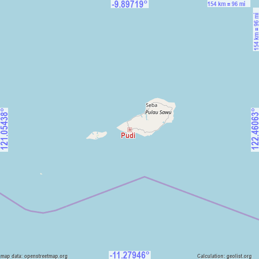
| Upper-left | -9.89719°, | 121.05438° |
| Center: | -10.5891°, | 121.7575° |
| Lower-right: | -11.27946°, | 122.46063° |
| Map W x H: | 153.7×153.7 km | = 95.5×95.5mi |
| max Lat: | 5.88969° ⇑99.1% North |
| Pudi: | -10.5891° |
| min Lat: | ⇓0.9% South -10.934° |
| min Long | Pudi | max Long |
| 95.1345° | 121.7575° | 140.9419° |
| W 87.4%⇐ | ⇒12.6% E |
Elevation
Elevation of Pudi is 150 m = 492 ft, and this is 79.7 m = 261 ft below average elevation for this country.
| Max E: |
3185 m = 10449 ft | 41.5% |
| Avg. | 229.7 m = 754 ft | |
| Pudi | 150 m = 492 ft | |
Min E: |
-1 m = -3 ft | 58.5% |
See also: Indonesia elevation on elevation.city.
Geographical zone
Pudi is located in South Torrid zone (between Equator and Tropic of Capricorn). Distance of Equator is 1177.4 km =731.6 mi to North.| Distance of | km | miles | from Pudi |
|---|---|---|---|
| Equator | 1177.4 | 731.6 | to North |
| Tropic Capricorn | 1428.5 | 887.6 | to South |
| Antarctic Circle | 6223.8 | 3867.3 | to South |
| South Pole | 8829.7 | 5486.5 | to South |


Nearby cities:
15 places around Pudi: (largest is in red/bold)
• Aimadamodo
5.4 km =3.4 mi,  81°
81°
• Danidehe
7.3 km =4.5 mi,  106°
106°
• Danirai
2.7 km =1.7 mi,  310°
310°
• Duku
11.5 km =7.1 mi,  94°
94°
• Gelanalalu
3.3 km =2.1 mi,  118°
118°
• Lederaba
4.3 km =2.7 mi,  293°
293°
• Lenakapa
1.4 km =0.9 mi,  188°
188°
• Ligu
5.2 km =3.2 mi,  358°
358°
• Mehona
8.3 km =5.2 mi, 94°
• Para
3.1 km =1.9 mi,  253°
253°
• Raehawu
10.2 km =6.3 mi,  52°
52°
• Raeliu
10.2 km =6.3 mi,  34°
34°
• Raemude
10.7 km =6.6 mi,  67°
67°
• Raenalulu
6.8 km =4.2 mi,  61°
61°
• Ubajami
8.6 km =5.3 mi,  23°
23°
Sources, notices
• [Note1] Compared only with cities in Indonesia existing in our database
• [Src1] Map data: © OpenStreetMap contributors (CC-BY-SA)
• [Src2] Other city data from geonames.org with taken over terms of usage.
• [Src3] Geographical zone / Annual Mean Temperature by Robert A. Rohde @ Wikipedia
