Guluhawu geodata
Guluhawu (East Nusa Tenggara) is a seat of a fourth-order administrative division; located in Indonesia in Asia/Makassar (GMT+8) time zone. In our database, there are 407 cities with bigger population. Compared to other cities in Indonesia, 98.8% of cities are located further ↑North; 88% of cities are located further ←West and 56.3% of cities have higher elevation than Guluhawu. Note1


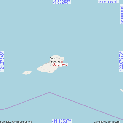
Guluhawu GPS coordinates[2]
10° 29' 41.28" South, 121° 58' 35.76" East
| Map corner | latitude | longitude |
|---|---|---|
| Upper-left | -9.80268°, | 121.27348° |
| Center: | -10.4948°, | 121.9766° |
| Lower-right: | -11.18537°, | 122.67973° |
| Map W x H: | 153.7×153.7 km | = 95.5×95.5mi |
| max Lat: | 5.88969° ⇑98.8% North |
| Guluhawu: | -10.4948° |
| min Lat: | ⇓1.2% South -10.934° |
| min Long | Guluhawu | max Long |
| 95.1345° | 121.9766° | 140.9419° |
| W 88%⇐ | ⇒12% E |
Elevation
Elevation of Guluhawu is 77 m = 253 ft, and this is 152.7 m = 501 ft below average elevation for this country.
| Max E: |
3185 m = 10449 ft | 56.3% |
| Avg. | 229.7 m = 754 ft | |
| Guluhawu | 77 m = 253 ft | |
Min E: |
-1 m = -3 ft | 43.7% |
See also: Indonesia elevation on elevation.city.
Geographical zone
Guluhawu is located in South Torrid zone (between Equator and Tropic of Capricorn). Distance of Equator is 1166.9 km =725.1 mi to North.| Distance of | km | miles | from Guluhawu |
|---|---|---|---|
| Equator | 1166.9 | 725.1 | to North |
| Tropic Capricorn | 1439 | 894.2 | to South |
| Antarctic Circle | 6234.3 | 3873.8 | to South |
| South Pole | 8840.1 | 5493 | to South |


Nearby cities:
15 places around Guluhawu: (largest is in red/bold)
• Ba
2.3 km =1.4 mi,  32°
32°
• Bolou
0.5 km =0.3 mi,  226°
226°
• Daikela
11.8 km =7.3 mi, 226°
• Dinititi
13.8 km =8.6 mi,  261°
261°
• Eikapaka
13.5 km =8.4 mi,  267°
267°
• Eilau
6.3 km =3.9 mi,  206°
206°
• Jarada
5 km =3.1 mi, 231°
• Jiwuwu
3.9 km =2.4 mi,  332°
332°
• Kahabe
9.5 km =5.9 mi, 211°
• Loboma
3.2 km =2 mi,  199°
199°
• Lokorae
8.7 km =5.4 mi,  243°
243°
• Nahura
12.3 km =7.6 mi,  287°
287°
• Padadue
4.6 km =2.9 mi, 264°
• Raejeru
6.2 km =3.9 mi,  314°
314°
• Unukume
0.9 km =0.6 mi,  167°
167°
Sources, notices
• [Note1] Compared only with cities in Indonesia existing in our database
• [Src1] Map data: © OpenStreetMap contributors (CC-BY-SA)
• [Src2] Other city data from geonames.org with taken over terms of usage.
• [Src3] Geographical zone / Annual Mean Temperature by Robert A. Rohde @ Wikipedia
