Oemaulain geodata
Oemaulain (East Nusa Tenggara) is a seat of a fourth-order administrative division; located in Indonesia in Asia/Makassar (GMT+8) time zone. In our database, there are 407 cities with bigger population. Compared to other cities in Indonesia, 99.6% of cities are located further ↑North; 90.4% of cities are located further ←West and 55.7% of cities have higher elevation than Oemaulain. Note1


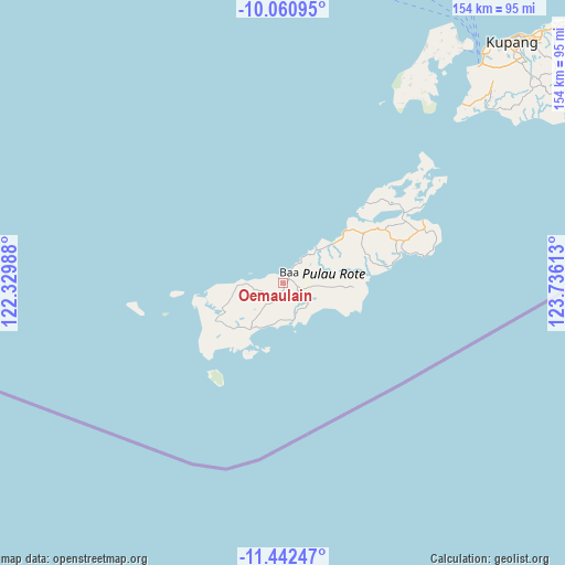
Oemaulain GPS coordinates[2]
10° 45' 9" South, 123° 1' 58.8" East
| Map corner | latitude | longitude |
|---|---|---|
| Upper-left | -10.06095°, | 122.32988° |
| Center: | -10.7525°, | 123.033° |
| Lower-right: | -11.44247°, | 123.73613° |
| Map W x H: | 153.6×153.6 km | = 95.4×95.4mi |
| max Lat: | 5.88969° ⇑99.6% North |
| Oemaulain: | -10.7525° |
| min Lat: | ⇓0.4% South -10.934° |
| min Long | Oemaulain | max Long |
| 95.1345° | 123.033° | 140.9419° |
| W 90.4%⇐ | ⇒9.6% E |
Elevation
Elevation of Oemaulain is 80 m = 262 ft, and this is 149.7 m = 491 ft below average elevation for this country.
| Max E: |
3185 m = 10449 ft | 55.7% |
| Avg. | 229.7 m = 754 ft | |
| Oemaulain | 80 m = 262 ft | |
Min E: |
-1 m = -3 ft | 44.3% |
See also: Indonesia elevation on elevation.city.
Geographical zone
Oemaulain is located in South Torrid zone (between Equator and Tropic of Capricorn). Distance of Equator is 1195.6 km =742.9 mi to North.| Distance of | km | miles | from Oemaulain |
|---|---|---|---|
| Equator | 1195.6 | 742.9 | to North |
| Tropic Capricorn | 1410.4 | 876.4 | to South |
| Antarctic Circle | 6205.6 | 3856 | to South |
| South Pole | 8811.5 | 5475.2 | to South |


Nearby cities:
15 places around Oemaulain: (largest is in red/bold)
• Alukama
1.8 km =1.1 mi,  54°
54°
• Asamboka
2.3 km =1.4 mi,  181°
181°
• Baa
3.4 km =2.1 mi,  31°
31°
• Busalangga
6.6 km =4.1 mi,  209°
209°
• Daudulu
5.4 km =3.4 mi,  280°
280°
• Lekik
7.7 km =4.8 mi,  106°
106°
• Likioen
1.3 km =0.8 mi,  70°
70°
• Netenain
8.5 km =5.3 mi,  260°
260°
• Nggalai Barat
8.7 km =5.4 mi,  189°
189°
• Oebaffok Satu
8.8 km =5.5 mi,  218°
218°
• Oebatu
7.2 km =4.5 mi,  197°
197°
• Oelunggu Satu
4.4 km =2.7 mi,  55°
55°
• Oetutulul
5.5 km =3.4 mi,  245°
245°
• Potikosin
7.7 km =4.8 mi, 66°
• Sanggaoen
1.9 km =1.2 mi,  142°
142°
Sources, notices
• [Note1] Compared only with cities in Indonesia existing in our database
• [Src1] Map data: © OpenStreetMap contributors (CC-BY-SA)
• [Src2] Other city data from geonames.org with taken over terms of usage.
• [Src3] Geographical zone / Annual Mean Temperature by Robert A. Rohde @ Wikipedia
