Sanggaoen geodata
Sanggaoen (East Nusa Tenggara) is a seat of a fourth-order administrative division; located in Indonesia in Asia/Makassar (GMT+8) time zone. In our database, there are 407 cities with bigger population. Compared to other cities in Indonesia, 99.6% of cities are located further ↑North; 90.5% of cities are located further ←West and 55.6% of cities have lower elevation than Sanggaoen. Note1


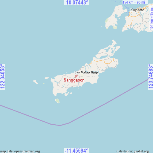
Sanggaoen GPS coordinates[2]
10° 45' 57.6" South, 123° 2' 37.32" East
| Map corner | latitude | longitude |
|---|---|---|
| Upper-left | -10.07448°, | 122.34058° |
| Center: | -10.766°, | 123.0437° |
| Lower-right: | -11.45594°, | 123.74683° |
| Map W x H: | 153.6×153.6 km | = 95.4×95.4mi |
| max Lat: | 5.88969° ⇑99.6% North |
| Sanggaoen: | -10.766° |
| min Lat: | ⇓0.4% South -10.934° |
| min Long | Sanggaoen | max Long |
| 95.1345° | 123.0437° | 140.9419° |
| W 90.5%⇐ | ⇒9.5% E |
Elevation
Elevation of Sanggaoen is 128 m = 420 ft, and this is 101.7 m = 334 ft below average elevation for this country.
| Max E: |
3185 m = 10449 ft | 44.4% |
| Avg. | 229.7 m = 754 ft | |
| Sanggaoen | 128 m = 420 ft | |
Min E: |
-1 m = -3 ft | 55.6% |
See also: Indonesia elevation on elevation.city.
Geographical zone
Sanggaoen is located in South Torrid zone (between Equator and Tropic of Capricorn). Distance of Equator is 1197.1 km =743.8 mi to North.| Distance of | km | miles | from Sanggaoen |
|---|---|---|---|
| Equator | 1197.1 | 743.8 | to North |
| Tropic Capricorn | 1408.9 | 875.4 | to South |
| Antarctic Circle | 6204.1 | 3855 | to South |
| South Pole | 8810 | 5474.3 | to South |


Nearby cities:
15 places around Sanggaoen: (largest is in red/bold)
• Alukama
2.6 km =1.6 mi,  6°
6°
• Asamboka
1.4 km =0.9 mi,  236°
236°
• Baa
4.5 km =2.8 mi, 7°
• Busalangga
6.1 km =3.8 mi,  226°
226°
• Daudulu
6.9 km =4.3 mi,  290°
290°
• Lekik
6.2 km =3.9 mi,  96°
96°
• Likioen
2 km =1.2 mi,  2°
2°
• Nggalai Barat
7.5 km =4.7 mi,  200°
200°
• Oebaffok Satu
8.6 km =5.3 mi, 231°
• Oebatu
6.3 km =3.9 mi,  212°
212°
• Oelunggu Satu
4.7 km =2.9 mi,  31°
31°
• Oemaulain
1.9 km =1.2 mi,  322°
322°
• Oetutulul
6.2 km =3.9 mi,  262°
262°
• Potikosin
7.5 km =4.7 mi,  52°
52°
• Souktuanan
7 km =4.3 mi,  142°
142°
Sources, notices
• [Note1] Compared only with cities in Indonesia existing in our database
• [Src1] Map data: © OpenStreetMap contributors (CC-BY-SA)
• [Src2] Other city data from geonames.org with taken over terms of usage.
• [Src3] Geographical zone / Annual Mean Temperature by Robert A. Rohde @ Wikipedia
