Karanganyar geodata
Karanganyar (East Java) is a seat of a fourth-order administrative division; located in Indonesia in Asia/Jakarta (GMT+7) time zone. In our database, there are 407 cities with bigger population. Compared to other cities in Indonesia, 66% of cities are located further ↓South; 66.7% of cities are located further ←West and 85.2% of cities have higher elevation than Karanganyar. Note1


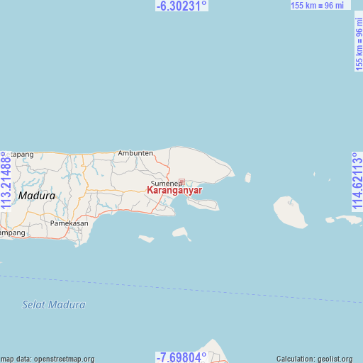
Karanganyar GPS coordinates[2]
7° 0' 2.52" South, 113° 55' 4.8" East
| Map corner | latitude | longitude |
|---|---|---|
| Upper-left | -6.30231°, | 113.21488° |
| Center: | -7.0007°, | 113.918° |
| Lower-right: | -7.69804°, | 114.62113° |
| Map W x H: | 155.2×155.2 km | = 96.4×96.4mi |
| max Lat: | 5.88969° ⇑34% North |
| Karanganyar: | -7.0007° |
| min Lat: | ⇓66% South -10.934° |
| min Long | Karanganyar | max Long |
| 95.1345° | 113.918° | 140.9419° |
| W 66.7%⇐ | ⇒33.3% E |
Elevation
Elevation of Karanganyar is 14 m = 46 ft, and this is 215.7 m = 708 ft below average elevation for this country.
| Max E: |
3185 m = 10449 ft | 85.2% |
| Avg. | 229.7 m = 754 ft | |
| Karanganyar | 14 m = 46 ft | |
Min E: |
-1 m = -3 ft | 14.8% |
See also: Indonesia elevation on elevation.city.
Geographical zone
Karanganyar is located in South Torrid zone (between Equator and Tropic of Capricorn). Distance of Equator is 778.4 km =483.7 mi to North.| Distance of | km | miles | from Karanganyar |
|---|---|---|---|
| Equator | 778.4 | 483.7 | to North |
| Tropic Capricorn | 1827.5 | 1135.6 | to South |
| Antarctic Circle | 6622.8 | 4115.2 | to South |
| South Pole | 9228.7 | 5734.4 | to South |


Nearby cities:
15 places around Karanganyar: (largest is in red/bold)
• Ahadan
2.7 km =1.7 mi,  82°
82°
• Ares Tengah
3.1 km =1.9 mi,  2°
2°
• Batujaran
1.8 km =1.1 mi,  296°
296°
• Bereklorong
4 km =2.5 mi,  197°
197°
• Cemara
4.6 km =2.9 mi,  212°
212°
• Dajalorong
1.7 km =1.1 mi,  73°
73°
• Gapura
4.2 km =2.6 mi, 83°
• Kramat
2.4 km =1.5 mi, 81°
• Mecadan
0.8 km =0.5 mi,  88°
88°
• Pandaringan Barat
3 km =1.9 mi,  273°
273°
• Panggung
3 km =1.9 mi, 83°
• Patenongan
4.1 km =2.5 mi, 269°
• Penatu
4.6 km =2.9 mi, 207°
• Raas
3.6 km =2.2 mi, 82°
• Talbantal
4.4 km =2.7 mi,  259°
259°
Sources, notices
• [Note1] Compared only with cities in Indonesia existing in our database
• [Src1] Map data: © OpenStreetMap contributors (CC-BY-SA)
• [Src2] Other city data from geonames.org with taken over terms of usage.
• [Src3] Geographical zone / Annual Mean Temperature by Robert A. Rohde @ Wikipedia
