Bereklorong geodata
Bereklorong (East Java) is a seat of a fourth-order administrative division; located in Indonesia in Asia/Jakarta (GMT+7) time zone. In our database, there are 407 cities with bigger population. Compared to other cities in Indonesia, 63.7% of cities are located further ↓South; 66.6% of cities are located further ←West and 93.7% of cities have higher elevation than Bereklorong. Note1


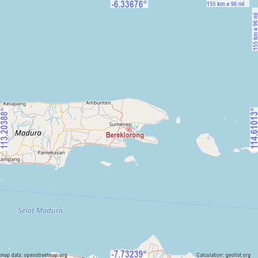
Bereklorong GPS coordinates[2]
7° 2' 6.36" South, 113° 54' 25.2" East
| Map corner | latitude | longitude |
|---|---|---|
| Upper-left | -6.33676°, | 113.20388° |
| Center: | -7.0351°, | 113.907° |
| Lower-right: | -7.73239°, | 114.61013° |
| Map W x H: | 155.2×155.2 km | = 96.4×96.4mi |
| max Lat: | 5.88969° ⇑36.3% North |
| Bereklorong: | -7.0351° |
| min Lat: | ⇓63.7% South -10.934° |
| min Long | Bereklorong | max Long |
| 95.1345° | 113.907° | 140.9419° |
| W 66.6%⇐ | ⇒33.4% E |
Elevation
Elevation of Bereklorong is 8 m = 26 ft, and this is 221.7 m = 727 ft below average elevation for this country.
| Max E: |
3185 m = 10449 ft | 93.7% |
| Avg. | 229.7 m = 754 ft | |
| Bereklorong | 8 m = 26 ft | |
Min E: |
-1 m = -3 ft | 6.3% |
See also: Indonesia elevation on elevation.city.
Geographical zone
Bereklorong is located in South Torrid zone (between Equator and Tropic of Capricorn). Distance of Equator is 782.2 km =486 mi to North.| Distance of | km | miles | from Bereklorong |
|---|---|---|---|
| Equator | 782.2 | 486 | to North |
| Tropic Capricorn | 1823.7 | 1133.2 | to South |
| Antarctic Circle | 6618.9 | 4112.8 | to South |
| South Pole | 9224.8 | 5732 | to South |


Nearby cities:
15 places around Bereklorong: (largest is in red/bold)
• Batujaran
4.7 km =2.9 mi,  354°
354°
• Cemara
1.3 km =0.8 mi,  265°
265°
• Kalianget
4.4 km =2.7 mi,  117°
117°
• Karanganyar
4 km =2.5 mi,  17°
17°
• Kebunkelapa
2.5 km =1.6 mi,  112°
112°
• Masjid
1.3 km =0.8 mi,  253°
253°
• Mecadan
4.3 km =2.7 mi,  27°
27°
• Padurekso
4.1 km =2.5 mi, 110°
• Palebunan
3.9 km =2.4 mi,  232°
232°
• Pandaringan Barat
4.4 km =2.7 mi,  335°
335°
• Pasarkayu
2.9 km =1.8 mi,  287°
287°
• Patenongan
4.8 km =3 mi,  323°
323°
• Penatu
0.9 km =0.6 mi, 251°
• Sumenep
4.9 km =3 mi, 294°
• Talbantal
4.3 km =2.7 mi,  314°
314°
Sources, notices
• [Note1] Compared only with cities in Indonesia existing in our database
• [Src1] Map data: © OpenStreetMap contributors (CC-BY-SA)
• [Src2] Other city data from geonames.org with taken over terms of usage.
• [Src3] Geographical zone / Annual Mean Temperature by Robert A. Rohde @ Wikipedia
