Kandang geodata
Kandang (East Java) is a seat of a fourth-order administrative division; located in Indonesia in Asia/Jakarta (GMT+7) time zone. In our database, there are 407 cities with bigger population. Compared to other cities in Indonesia, 70.6% of cities are located further ↓South; 58.4% of cities are located further ←West and 73.4% of cities have higher elevation than Kandang. Note1


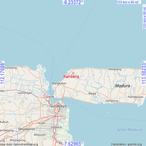
Kandang GPS coordinates[2]
6° 55' 55.92" South, 112° 52' 45.12" East
| Map corner | latitude | longitude |
|---|---|---|
| Upper-left | -6.23372°, | 112.17608° |
| Center: | -6.9322°, | 112.8792° |
| Lower-right: | -7.62965°, | 113.58233° |
| Map W x H: | 155.2×155.2 km | = 96.4×96.4mi |
| max Lat: | 5.88969° ⇑29.4% North |
| Kandang: | -6.9322° |
| min Lat: | ⇓70.6% South -10.934° |
| min Long | Kandang | max Long |
| 95.1345° | 112.8792° | 140.9419° |
| W 58.4%⇐ | ⇒41.6% E |
Elevation
Elevation of Kandang is 27 m = 89 ft, and this is 202.7 m = 665 ft below average elevation for this country.
| Max E: |
3185 m = 10449 ft | 73.4% |
| Avg. | 229.7 m = 754 ft | |
| Kandang | 27 m = 89 ft | |
Min E: |
-1 m = -3 ft | 26.6% |
See also: Indonesia elevation on elevation.city.
Geographical zone
Kandang is located in South Torrid zone (between Equator and Tropic of Capricorn). Distance of Equator is 770.8 km =479 mi to North.| Distance of | km | miles | from Kandang |
|---|---|---|---|
| Equator | 770.8 | 479 | to North |
| Tropic Capricorn | 1835.1 | 1140.3 | to South |
| Antarctic Circle | 6630.4 | 4119.9 | to South |
| South Pole | 9236.3 | 5739.2 | to South |


Nearby cities:
15 places around Kandang: (largest is in red/bold)
• Ambat
1.4 km =0.9 mi,  42°
42°
• Basen
3.2 km =2 mi,  186°
186°
• Berbeluk Timur
3.8 km =2.4 mi,  206°
206°
• Bragang Tengah
2.9 km =1.8 mi,  96°
96°
• Doroagung
3.5 km =2.2 mi, 185°
• Gintongan
3 km =1.9 mi,  328°
328°
• Karangasem Laok
1.8 km =1.1 mi,  256°
256°
• Makan
3 km =1.9 mi,  232°
232°
• Nakajah
3.9 km =2.4 mi,  113°
113°
• Polongan Daja
1.8 km =1.1 mi,  237°
237°
• Raas
3.7 km =2.3 mi,  277°
277°
• Rojing
2.7 km =1.7 mi,  8°
8°
• Sebuh
2.9 km =1.8 mi,  300°
300°
• Tambeggan Satu
3.7 km =2.3 mi, 228°
• Trogan Barat
2.3 km =1.4 mi,  294°
294°
Sources, notices
• [Note1] Compared only with cities in Indonesia existing in our database
• [Src1] Map data: © OpenStreetMap contributors (CC-BY-SA)
• [Src2] Other city data from geonames.org with taken over terms of usage.
• [Src3] Geographical zone / Annual Mean Temperature by Robert A. Rohde @ Wikipedia
