Balong geodata
Balong (East Java) is a seat of a fourth-order administrative division; located in Indonesia in Asia/Jakarta (GMT+7) time zone. In our database, there are 407 cities with bigger population. Compared to other cities in Indonesia, 73.2% of cities are located further ↓South; 58.5% of cities are located further ←West and 98.5% of cities have higher elevation than Balong. Note1


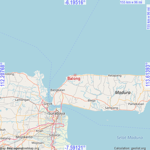
Balong GPS coordinates[2]
6° 53' 37.32" South, 112° 54' 38.88" East
| Map corner | latitude | longitude |
|---|---|---|
| Upper-left | -6.19516°, | 112.20768° |
| Center: | -6.8937°, | 112.9108° |
| Lower-right: | -7.59121°, | 113.61393° |
| Map W x H: | 155.2×155.2 km | = 96.4×96.4mi |
| max Lat: | 5.88969° ⇑26.8% North |
| Balong: | -6.8937° |
| min Lat: | ⇓73.2% South -10.934° |
| min Long | Balong | max Long |
| 95.1345° | 112.9108° | 140.9419° |
| W 58.5%⇐ | ⇒41.5% E |
Elevation
Elevation of Balong is 5 m = 16 ft, and this is 224.7 m = 737 ft below average elevation for this country.
| Max E: |
3185 m = 10449 ft | 98.5% |
| Avg. | 229.7 m = 754 ft | |
| Balong | 5 m = 16 ft | |
Min E: |
-1 m = -3 ft | 1.5% |
See also: Indonesia elevation on elevation.city.
Geographical zone
Balong is located in South Torrid zone (between Equator and Tropic of Capricorn). Distance of Equator is 766.5 km =476.3 mi to North.| Distance of | km | miles | from Balong |
|---|---|---|---|
| Equator | 766.5 | 476.3 | to North |
| Tropic Capricorn | 1839.4 | 1142.9 | to South |
| Antarctic Circle | 6634.7 | 4122.6 | to South |
| South Pole | 9240.6 | 5741.8 | to South |


Nearby cities:
15 places around Balong: (largest is in red/bold)
• Ambat
4.1 km =2.5 mi,  218°
218°
• Bator
1 km =0.6 mi,  253°
253°
• Birempa
1.6 km =1 mi,  117°
117°
• Bragang Tengah
4.6 km =2.9 mi,  187°
187°
• Gintongan
5.3 km =3.3 mi, 251°
• Glugur
3.3 km =2.1 mi,  173°
173°
• Jeleuk
5.9 km =3.7 mi,  89°
89°
• Kandang
5.5 km =3.4 mi, 219°
• Karang
3.2 km =2 mi, 93°
• Klampis
0.7 km =0.4 mi,  269°
269°
• Laranganglintong
2.4 km =1.5 mi,  96°
96°
• Nakajah
5.8 km =3.6 mi,  179°
179°
• Rojing
3.5 km =2.2 mi,  243°
243°
• Sepulu
5.4 km =3.4 mi, 94°
• Tenggun Dajah
0.8 km =0.5 mi, 117°
Sources, notices
• [Note1] Compared only with cities in Indonesia existing in our database
• [Src1] Map data: © OpenStreetMap contributors (CC-BY-SA)
• [Src2] Other city data from geonames.org with taken over terms of usage.
• [Src3] Geographical zone / Annual Mean Temperature by Robert A. Rohde @ Wikipedia
