Labang geodata
Labang (East Java) is a seat of a fourth-order administrative division; located in Indonesia in Asia/Jakarta (GMT+7) time zone. In our database, there are 407 cities with bigger population. Compared to other cities in Indonesia, 69.8% of cities are located further ↓South; 58.7% of cities are located further ←West and 52.3% of cities have higher elevation than Labang. Note1


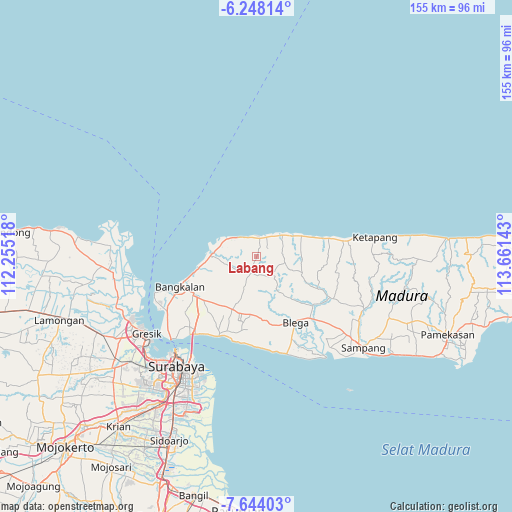
Labang GPS coordinates[2]
6° 56' 47.76" South, 112° 57' 29.88" East
| Map corner | latitude | longitude |
|---|---|---|
| Upper-left | -6.24814°, | 112.25518° |
| Center: | -6.9466°, | 112.9583° |
| Lower-right: | -7.64403°, | 113.66143° |
| Map W x H: | 155.2×155.2 km | = 96.4×96.4mi |
| max Lat: | 5.88969° ⇑30.2% North |
| Labang: | -6.9466° |
| min Lat: | ⇓69.8% South -10.934° |
| min Long | Labang | max Long |
| 95.1345° | 112.9583° | 140.9419° |
| W 58.7%⇐ | ⇒41.3% E |
Elevation
Elevation of Labang is 94 m = 308 ft, and this is 135.7 m = 445 ft below average elevation for this country.
| Max E: |
3185 m = 10449 ft | 52.3% |
| Avg. | 229.7 m = 754 ft | |
| Labang | 94 m = 308 ft | |
Min E: |
-1 m = -3 ft | 47.7% |
See also: Indonesia elevation on elevation.city.
Geographical zone
Labang is located in South Torrid zone (between Equator and Tropic of Capricorn). Distance of Equator is 772.4 km =479.9 mi to North.| Distance of | km | miles | from Labang |
|---|---|---|---|
| Equator | 772.4 | 479.9 | to North |
| Tropic Capricorn | 1833.5 | 1139.3 | to South |
| Antarctic Circle | 6628.8 | 4118.9 | to South |
| South Pole | 9234.7 | 5738.2 | to South |


Nearby cities:
15 places around Labang: (largest is in red/bold)
• Baratleke
4.2 km =2.6 mi,  96°
96°
• Bindang
3.3 km =2.1 mi,  6°
6°
• Cangkreng
2.3 km =1.4 mi,  176°
176°
• Gangseyan
1.4 km =0.9 mi,  287°
287°
• Glugur
5.5 km =3.4 mi,  298°
298°
• Koronganayam
4 km =2.5 mi,  208°
208°
• Lendan
5.1 km =3.2 mi,  15°
15°
• Longka
0.8 km =0.5 mi,  83°
83°
• Nakajah
5.2 km =3.2 mi,  270°
270°
• Pakes
3.6 km =2.2 mi,  125°
125°
• Palenggihan
3.8 km =2.4 mi,  242°
242°
• Rukgaruk
4.9 km =3 mi, 100°
• Sahplasah
5.1 km =3.2 mi,  119°
119°
• Sepulu
5.4 km =3.4 mi,  1°
1°
• Terbuh
5.9 km =3.7 mi,  258°
258°
Sources, notices
• [Note1] Compared only with cities in Indonesia existing in our database
• [Src1] Map data: © OpenStreetMap contributors (CC-BY-SA)
• [Src2] Other city data from geonames.org with taken over terms of usage.
• [Src3] Geographical zone / Annual Mean Temperature by Robert A. Rohde @ Wikipedia
