Kuanheum geodata
Kuanheum (East Nusa Tenggara) is a seat of a fourth-order administrative division; located in Indonesia in Asia/Makassar (GMT+8) time zone. In our database, there are 407 cities with bigger population. Compared to other cities in Indonesia, 97.9% of cities are located further ↑North; 94.1% of cities are located further ←West and 59.1% of cities have lower elevation than Kuanheum. Note1


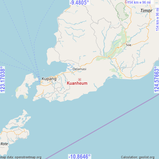
Kuanheum GPS coordinates[2]
10° 10' 23.88" South, 123° 52' 24.6" East
| Map corner | latitude | longitude |
|---|---|---|
| Upper-left | -9.4805°, | 123.17038° |
| Center: | -10.1733°, | 123.8735° |
| Lower-right: | -10.8646°, | 124.57663° |
| Map W x H: | 153.9×153.9 km | = 95.6×95.6mi |
| max Lat: | 5.88969° ⇑97.9% North |
| Kuanheum: | -10.1733° |
| min Lat: | ⇓2.1% South -10.934° |
| min Long | Kuanheum | max Long |
| 95.1345° | 123.8735° | 140.9419° |
| W 94.1%⇐ | ⇒5.9% E |
Elevation
Elevation of Kuanheum is 154 m = 505 ft, and this is 75.7 m = 248 ft below average elevation for this country.
| Max E: |
3185 m = 10449 ft | 40.9% |
| Avg. | 229.7 m = 754 ft | |
| Kuanheum | 154 m = 505 ft | |
Min E: |
-1 m = -3 ft | 59.1% |
See also: Indonesia elevation on elevation.city.
Geographical zone
Kuanheum is located in South Torrid zone (between Equator and Tropic of Capricorn). Distance of Equator is 1131.2 km =702.9 mi to North.| Distance of | km | miles | from Kuanheum |
|---|---|---|---|
| Equator | 1131.2 | 702.9 | to North |
| Tropic Capricorn | 1474.8 | 916.4 | to South |
| Antarctic Circle | 6270 | 3896 | to South |
| South Pole | 8875.9 | 5515.2 | to South |


Nearby cities:
15 places around Kuanheum: (largest is in red/bold)
• Buka
7.9 km =4.9 mi,  121°
121°
• Fatukanutu
3 km =1.9 mi,  80°
80°
• Hauhena
8.2 km =5.1 mi,  143°
143°
• Hausisi
8.7 km =5.4 mi,  216°
216°
• Kairane
8 km =5 mi, 75°
• Kiukasen
5.7 km =3.5 mi,  38°
38°
• Nis’oni
4.8 km =3 mi,  320°
320°
• Oekabiti
7 km =4.3 mi,  228°
228°
• Oesao
9 km =5.6 mi,  311°
311°
• Oibioin
7.4 km =4.6 mi, 229°
• Ponain
4.5 km =2.8 mi,  211°
211°
• Pukdale
7.5 km =4.7 mi, 322°
• Tanbira
4 km =2.5 mi,  161°
161°
• Tuamese
8 km =5 mi,  178°
178°
• Tuatuka
4.6 km =2.9 mi,  296°
296°
Sources, notices
• [Note1] Compared only with cities in Indonesia existing in our database
• [Src1] Map data: © OpenStreetMap contributors (CC-BY-SA)
• [Src2] Other city data from geonames.org with taken over terms of usage.
• [Src3] Geographical zone / Annual Mean Temperature by Robert A. Rohde @ Wikipedia
