Fuan geodata
Fuan (East Nusa Tenggara) is a seat of a fourth-order administrative division; located in Indonesia in Asia/Makassar (GMT+8) time zone. In our database, there are 407 cities with bigger population. Compared to other cities in Indonesia, 98.2% of cities are located further ↑North; 93.7% of cities are located further ←West and 68.8% of cities have lower elevation than Fuan. Note1


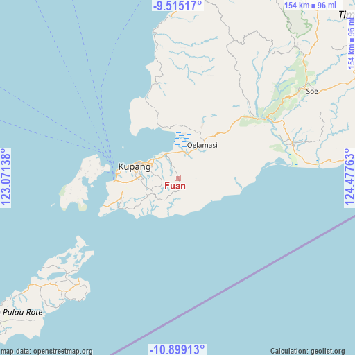
Fuan GPS coordinates[2]
10° 12' 28.44" South, 123° 46' 28.2" East
| Map corner | latitude | longitude |
|---|---|---|
| Upper-left | -9.51517°, | 123.07138° |
| Center: | -10.2079°, | 123.7745° |
| Lower-right: | -10.89913°, | 124.47763° |
| Map W x H: | 153.9×153.9 km | = 95.6×95.6mi |
| max Lat: | 5.88969° ⇑98.2% North |
| Fuan: | -10.2079° |
| min Lat: | ⇓1.8% South -10.934° |
| min Long | Fuan | max Long |
| 95.1345° | 123.7745° | 140.9419° |
| W 93.7%⇐ | ⇒6.3% E |
Elevation
Elevation of Fuan is 277 m = 909 ft, and this is 47.3 m = 155 ft above average elevation for this country.
| Max E: |
3185 m = 10449 ft | 31.2% |
| Fuan | 277 m 909 ft | |
| Avg. | 229.7 m = 754 ft | |
Min E: |
-1 m = -3 ft | 68.8% |
See also: Indonesia elevation on elevation.city.
Geographical zone
Fuan is located in South Torrid zone (between Equator and Tropic of Capricorn). Distance of Equator is 1135 km =705.3 mi to North.| Distance of | km | miles | from Fuan |
|---|---|---|---|
| Equator | 1135 | 705.3 | to North |
| Tropic Capricorn | 1470.9 | 914 | to South |
| Antarctic Circle | 6266.2 | 3893.6 | to South |
| South Pole | 8872 | 5512.8 | to South |


Nearby cities:
15 places around Fuan: (largest is in red/bold)
• Banupo
7.1 km =4.4 mi,  3°
3°
• Batuna Satu
5.2 km =3.2 mi,  178°
178°
• Baumata
9.5 km =5.9 mi,  276°
276°
• Bijaenaka
7.3 km =4.5 mi,  335°
335°
• Hausisi
6.4 km =4 mi,  118°
118°
• Kolomanu
9.1 km =5.7 mi,  245°
245°
• Mekon
10.7 km =6.6 mi,  297°
297°
• Oehani
7.6 km =4.7 mi, 249°
• Oekabiti
5.6 km =3.5 mi,  98°
98°
• Oesao
10.6 km =6.6 mi,  22°
22°
• Oibioin
5.3 km =3.3 mi, 100°
• Ponain
8.5 km =5.3 mi,  89°
89°
• Potibaun
8.5 km =5.3 mi,  206°
206°
• Soba
10.3 km =6.4 mi, 214°
• Tuatuka
8.9 km =5.5 mi,  48°
48°
Sources, notices
• [Note1] Compared only with cities in Indonesia existing in our database
• [Src1] Map data: © OpenStreetMap contributors (CC-BY-SA)
• [Src2] Other city data from geonames.org with taken over terms of usage.
• [Src3] Geographical zone / Annual Mean Temperature by Robert A. Rohde @ Wikipedia
