Oemanu geodata
Oemanu (East Nusa Tenggara) is a seat of a fourth-order administrative division; located in Indonesia in Asia/Makassar (GMT+8) time zone. In our database, there are 407 cities with bigger population. Compared to other cities in Indonesia, 96.4% of cities are located further ↑North; 95.2% of cities are located further ←West and 90.6% of cities have lower elevation than Oemanu. Note1


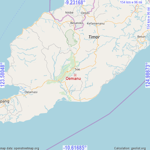
Oemanu GPS coordinates[2]
9° 55' 30" South, 124° 17' 0.96" East
| Map corner | latitude | longitude |
|---|---|---|
| Upper-left | -9.23168°, | 123.58048° |
| Center: | -9.925°, | 124.2836° |
| Lower-right: | -10.61685°, | 124.98673° |
| Map W x H: | 154×154 km | = 95.7×95.7mi |
| max Lat: | 5.88969° ⇑96.4% North |
| Oemanu: | -9.925° |
| min Lat: | ⇓3.6% South -10.934° |
| min Long | Oemanu | max Long |
| 95.1345° | 124.2836° | 140.9419° |
| W 95.2%⇐ | ⇒4.8% E |
Elevation
Elevation of Oemanu is 661 m = 2169 ft, and this is 431.3 m = 1415 ft above average elevation for this country.
| Max E: |
3185 m = 10449 ft | 9.4% |
| Oemanu | 661 m 2169 ft | |
| Avg. | 229.7 m = 754 ft | |
Min E: |
-1 m = -3 ft | 90.6% |
See also: Indonesia elevation on elevation.city.
Geographical zone
Oemanu is located in South Torrid zone (between Equator and Tropic of Capricorn). Distance of Equator is 1103.6 km =685.7 mi to North.| Distance of | km | miles | from Oemanu |
|---|---|---|---|
| Equator | 1103.6 | 685.7 | to North |
| Tropic Capricorn | 1502.4 | 933.5 | to South |
| Antarctic Circle | 6297.6 | 3913.1 | to South |
| South Pole | 8903.5 | 5532.4 | to South |


Nearby cities:
15 places around Oemanu: (largest is in red/bold)
• Hane
6.8 km =4.2 mi,  279°
279°
• Kampungbaru
6.9 km =4.3 mi,  356°
356°
• Mnelalete
5.3 km =3.3 mi,  34°
34°
• Nunumeu Timur
7.1 km =4.4 mi,  13°
13°
• Oeana
7 km =4.3 mi,  336°
336°
• Oebesa
6.5 km =4 mi, 6°
• Oekamusa
6.1 km =3.8 mi,  24°
24°
• Oekefan
7.2 km =4.5 mi, 5°
• Oepuah
6.3 km =3.9 mi, 19°
• Pusu
5.1 km =3.2 mi,  52°
52°
• Rote
6.6 km =4.1 mi,  351°
351°
• Soe
7.1 km =4.4 mi,  0°
0°
• Taubneno
7.1 km =4.4 mi, 1°
• Tuanalepe
3.8 km =2.4 mi,  116°
116°
• Tubuhue
6.1 km =3.8 mi,  316°
316°
Sources, notices
• [Note1] Compared only with cities in Indonesia existing in our database
• [Src1] Map data: © OpenStreetMap contributors (CC-BY-SA)
• [Src2] Other city data from geonames.org with taken over terms of usage.
• [Src3] Geographical zone / Annual Mean Temperature by Robert A. Rohde @ Wikipedia
