Jerukporot geodata
Jerukporot (East Java) is a seat of a fourth-order administrative division; located in Indonesia in Asia/Jakarta (GMT+7) time zone. In our database, there are 407 cities with bigger population. Compared to other cities in Indonesia, 70.1% of cities are located further ↓South; 67.2% of cities are located further ←West and 58.4% of cities have higher elevation than Jerukporot. Note1


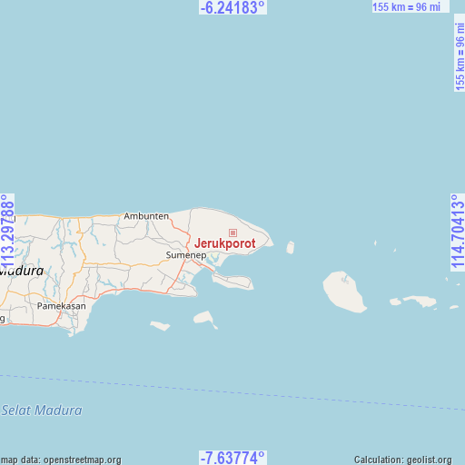
Jerukporot GPS coordinates[2]
6° 56' 25.08" South, 114° 0' 3.6" East
| Map corner | latitude | longitude |
|---|---|---|
| Upper-left | -6.24183°, | 113.29788° |
| Center: | -6.9403°, | 114.001° |
| Lower-right: | -7.63774°, | 114.70413° |
| Map W x H: | 155.2×155.2 km | = 96.4×96.4mi |
| max Lat: | 5.88969° ⇑29.9% North |
| Jerukporot: | -6.9403° |
| min Lat: | ⇓70.1% South -10.934° |
| min Long | Jerukporot | max Long |
| 95.1345° | 114.001° | 140.9419° |
| W 67.2%⇐ | ⇒32.8% E |
Elevation
Elevation of Jerukporot is 66 m = 217 ft, and this is 163.7 m = 537 ft below average elevation for this country.
| Max E: |
3185 m = 10449 ft | 58.4% |
| Avg. | 229.7 m = 754 ft | |
| Jerukporot | 66 m = 217 ft | |
Min E: |
-1 m = -3 ft | 41.6% |
See also: Indonesia elevation on elevation.city.
Geographical zone
Jerukporot is located in South Torrid zone (between Equator and Tropic of Capricorn). Distance of Equator is 771.7 km =479.5 mi to North.| Distance of | km | miles | from Jerukporot |
|---|---|---|---|
| Equator | 771.7 | 479.5 | to North |
| Tropic Capricorn | 1834.2 | 1139.7 | to South |
| Antarctic Circle | 6629.5 | 4119.4 | to South |
| South Pole | 9235.4 | 5738.6 | to South |


Nearby cities:
15 places around Jerukporot: (largest is in red/bold)
• Ares Tengah
1.3 km =0.8 mi,  152°
152°
• Jandir
2.4 km =1.5 mi,  199°
199°
• Jurangara
3.9 km =2.4 mi,  156°
156°
• Jurgang Timur
3.5 km =2.2 mi,  326°
326°
• Kalerker
4.6 km =2.9 mi,  57°
57°
• Karangkeng
2.2 km =1.4 mi, 60°
• Kayukembang
2.3 km =1.4 mi,  288°
288°
• Ngabungan
3.4 km =2.1 mi,  123°
123°
• Partikan
4.1 km =2.5 mi,  26°
26°
• Petong
4.6 km =2.9 mi,  143°
143°
• Poja
4.5 km =2.8 mi, 122°
• Samburat
5.4 km =3.4 mi,  48°
48°
• Sekolan
4.1 km =2.5 mi,  100°
100°
• Tekay
4.9 km =3 mi,  42°
42°
• Togu
3.8 km =2.4 mi,  240°
240°
Sources, notices
• [Note1] Compared only with cities in Indonesia existing in our database
• [Src1] Map data: © OpenStreetMap contributors (CC-BY-SA)
• [Src2] Other city data from geonames.org with taken over terms of usage.
• [Src3] Geographical zone / Annual Mean Temperature by Robert A. Rohde @ Wikipedia
