Malimaneek geodata
Malimaneek (East Nusa Tenggara) is a seat of a fourth-order administrative division; located in Indonesia in Asia/Makassar (GMT+8) time zone. In our database, there are 407 cities with bigger population. Compared to other cities in Indonesia, 94% of cities are located further ↑North; 97.7% of cities are located further ←West and 89% of cities have lower elevation than Malimaneek. Note1


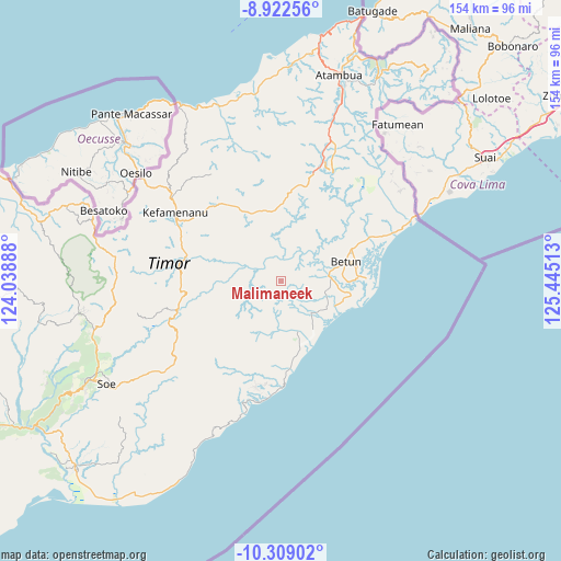
Malimaneek GPS coordinates[2]
9° 36' 59.4" South, 124° 44' 31.2" East
| Map corner | latitude | longitude |
|---|---|---|
| Upper-left | -8.92256°, | 124.03888° |
| Center: | -9.6165°, | 124.742° |
| Lower-right: | -10.30902°, | 125.44513° |
| Map W x H: | 154.2×154.2 km | = 95.8×95.8mi |
| max Lat: | 5.88969° ⇑94% North |
| Malimaneek: | -9.6165° |
| min Lat: | ⇓6% South -10.934° |
| min Long | Malimaneek | max Long |
| 95.1345° | 124.742° | 140.9419° |
| W 97.7%⇐ | ⇒2.3% E |
Elevation
Elevation of Malimaneek is 609 m = 1998 ft, and this is 379.3 m = 1244 ft above average elevation for this country.
| Max E: |
3185 m = 10449 ft | 11% |
| Malimaneek | 609 m 1998 ft | |
| Avg. | 229.7 m = 754 ft | |
Min E: |
-1 m = -3 ft | 89% |
See also: Indonesia elevation on elevation.city.
Geographical zone
Malimaneek is located in South Torrid zone (between Equator and Tropic of Capricorn). Distance of Equator is 1069.3 km =664.4 mi to North.| Distance of | km | miles | from Malimaneek |
|---|---|---|---|
| Equator | 1069.3 | 664.4 | to North |
| Tropic Capricorn | 1536.7 | 954.9 | to South |
| Antarctic Circle | 6331.9 | 3934.5 | to South |
| South Pole | 8937.8 | 5553.7 | to South |


Nearby cities:
15 places around Malimaneek: (largest is in red/bold)
• Ayotupas
9.7 km =6 mi,  202°
202°
• Besnam
10.1 km =6.3 mi,  247°
247°
• Biudukfoho
1.1 km =0.7 mi,  346°
346°
• Bonefatu
7.8 km =4.8 mi,  207°
207°
• Kiutoko
10 km =6.2 mi,  317°
317°
• Leof
13.6 km =8.5 mi,  288°
288°
• Maurisu
10.5 km =6.5 mi,  296°
296°
• Mmaaf
8.2 km =5.1 mi, 213°
• Mnelabano
13.3 km =8.3 mi,  216°
216°
• Nularan
8.4 km =5.2 mi,  272°
272°
• Oeleno
0.7 km =0.4 mi, 221°
• Oesoot
12.4 km =7.7 mi,  190°
190°
• Sonlit
7.1 km =4.4 mi,  181°
181°
• Tnaomat
9.9 km =6.2 mi, 205°
• Wekmurak
6.5 km =4 mi,  338°
338°
Sources, notices
• [Note1] Compared only with cities in Indonesia existing in our database
• [Src1] Map data: © OpenStreetMap contributors (CC-BY-SA)
• [Src2] Other city data from geonames.org with taken over terms of usage.
• [Src3] Geographical zone / Annual Mean Temperature by Robert A. Rohde @ Wikipedia
