Tnaomat geodata
Tnaomat (East Nusa Tenggara) is a seat of a fourth-order administrative division; located in Indonesia in Asia/Makassar (GMT+8) time zone. In our database, there are 407 cities with bigger population. Compared to other cities in Indonesia, 94.7% of cities are located further ↑North; 97.5% of cities are located further ←West and 84.2% of cities have lower elevation than Tnaomat. Note1


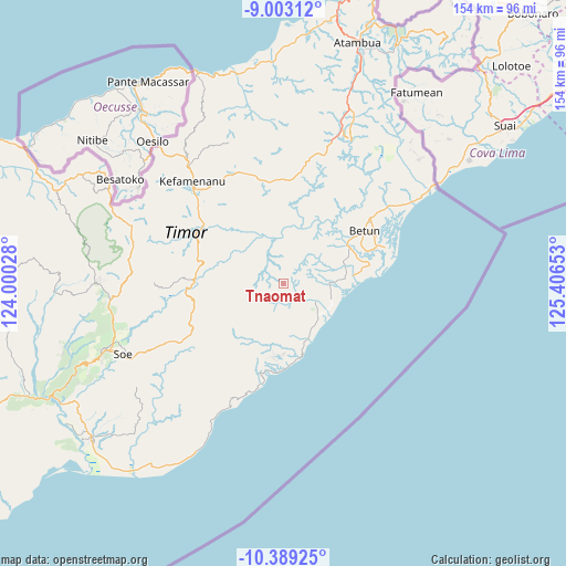
Tnaomat GPS coordinates[2]
9° 41' 48.84" South, 124° 42' 12.24" East
| Map corner | latitude | longitude |
|---|---|---|
| Upper-left | -9.00312°, | 124.00028° |
| Center: | -9.6969°, | 124.7034° |
| Lower-right: | -10.38925°, | 125.40653° |
| Map W x H: | 154.1×154.1 km | = 95.8×95.8mi |
| max Lat: | 5.88969° ⇑94.7% North |
| Tnaomat: | -9.6969° |
| min Lat: | ⇓5.3% South -10.934° |
| min Long | Tnaomat | max Long |
| 95.1345° | 124.7034° | 140.9419° |
| W 97.5%⇐ | ⇒2.5% E |
Elevation
Elevation of Tnaomat is 503 m = 1650 ft, and this is 273.3 m = 897 ft above average elevation for this country.
| Max E: |
3185 m = 10449 ft | 15.8% |
| Tnaomat | 503 m 1650 ft | |
| Avg. | 229.7 m = 754 ft | |
Min E: |
-1 m = -3 ft | 84.2% |
See also: Indonesia elevation on elevation.city.
Geographical zone
Tnaomat is located in South Torrid zone (between Equator and Tropic of Capricorn). Distance of Equator is 1078.2 km =670 mi to North.| Distance of | km | miles | from Tnaomat |
|---|---|---|---|
| Equator | 1078.2 | 670 | to North |
| Tropic Capricorn | 1527.7 | 949.3 | to South |
| Antarctic Circle | 6323 | 3928.9 | to South |
| South Pole | 8928.9 | 5548.2 | to South |


Nearby cities:
15 places around Tnaomat: (largest is in red/bold)
• Ayotupas
0.5 km =0.3 mi,  92°
92°
• Besnam
7.3 km =4.5 mi,  314°
314°
• Bonefatu
2.1 km =1.3 mi,  16°
16°
• Fotilo
4.6 km =2.9 mi,  193°
193°
• Malimaneek
9.9 km =6.2 mi,  25°
25°
• Mmaaf
2.2 km =1.4 mi,  351°
351°
• Mnelabano
4.1 km =2.5 mi,  244°
244°
• Noebana
9.8 km =6.1 mi,  210°
210°
• Oefenu
7.4 km =4.6 mi, 205°
• Oeleno
9.2 km =5.7 mi, 24°
• Oeleu
6.8 km =4.2 mi,  142°
142°
• Oesoot
3.8 km =2.4 mi,  147°
147°
• Poli
7.9 km =4.9 mi,  180°
180°
• Sonlit
4.5 km =2.8 mi,  65°
65°
• Tuateta
6.5 km =4 mi, 244°
Sources, notices
• [Note1] Compared only with cities in Indonesia existing in our database
• [Src1] Map data: © OpenStreetMap contributors (CC-BY-SA)
• [Src2] Other city data from geonames.org with taken over terms of usage.
• [Src3] Geographical zone / Annual Mean Temperature by Robert A. Rohde @ Wikipedia
