Lewolang geodata
Lewolang (East Nusa Tenggara) is a seat of a fourth-order administrative division; located in Indonesia in Asia/Makassar (GMT+8) time zone. In our database, there are 407 cities with bigger population. Compared to other cities in Indonesia, 75% of cities are located further ↑North; 96% of cities are located further ←West and 73.4% of cities have higher elevation than Lewolang. Note1


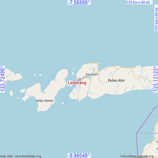
Lewolang GPS coordinates[2]
8° 15' 55.08" South, 124° 25' 41.16" East
| Map corner | latitude | longitude |
|---|---|---|
| Upper-left | -7.56888°, | 123.72498° |
| Center: | -8.2653°, | 124.4281° |
| Lower-right: | -8.96049°, | 125.13123° |
| Map W x H: | 154.7×154.7 km | = 96.1×96.1mi |
| max Lat: | 5.88969° ⇑75% North |
| Lewolang: | -8.2653° |
| min Lat: | ⇓25% South -10.934° |
| min Long | Lewolang | max Long |
| 95.1345° | 124.4281° | 140.9419° |
| W 96%⇐ | ⇒4% E |
Elevation
Elevation of Lewolang is 27 m = 89 ft, and this is 202.7 m = 665 ft below average elevation for this country.
| Max E: |
3185 m = 10449 ft | 73.4% |
| Avg. | 229.7 m = 754 ft | |
| Lewolang | 27 m = 89 ft | |
Min E: |
-1 m = -3 ft | 26.6% |
See also: Indonesia elevation on elevation.city.
Geographical zone
Lewolang is located in South Torrid zone (between Equator and Tropic of Capricorn). Distance of Equator is 919 km =571 mi to North.| Distance of | km | miles | from Lewolang |
|---|---|---|---|
| Equator | 919 | 571 | to North |
| Tropic Capricorn | 1686.9 | 1048.2 | to South |
| Antarctic Circle | 6482.2 | 4027.9 | to South |
| South Pole | 9088 | 5647 | to South |


Nearby cities:
15 places around Lewolang: (largest is in red/bold)
• Apuri
8.9 km =5.5 mi,  230°
230°
• Binongko
10.8 km =6.7 mi,  60°
60°
• Doibang
11.2 km =7 mi,  46°
46°
• Dulolong
2.4 km =1.5 mi, 61°
• Fa’aming
2.3 km =1.4 mi,  107°
107°
• Kampungraja
11.3 km =7 mi, 60°
• Kenarilang
9.5 km =5.9 mi, 58°
• Kikilai
10.4 km =6.5 mi,  89°
89°
• Kokar
11.6 km =7.2 mi,  10°
10°
• Maiwal
12 km =7.5 mi,  123°
123°
• Moru
9.7 km =6 mi,  84°
84°
• Pantaimakasar
2.1 km =1.3 mi,  257°
257°
• Seieng
9.2 km =5.7 mi,  3°
3°
• Solangbali
8.8 km =5.5 mi, 261°
• Ulimonong
3.8 km =2.4 mi,  318°
318°
Sources, notices
• [Note1] Compared only with cities in Indonesia existing in our database
• [Src1] Map data: © OpenStreetMap contributors (CC-BY-SA)
• [Src2] Other city data from geonames.org with taken over terms of usage.
• [Src3] Geographical zone / Annual Mean Temperature by Robert A. Rohde @ Wikipedia
