Lerahinga geodata
Lerahinga (East Nusa Tenggara) is a seat of a fourth-order administrative division; located in Indonesia in Asia/Makassar (GMT+8) time zone. In our database, there are 407 cities with bigger population. Compared to other cities in Indonesia, 79.4% of cities are located further ↑North; 92.6% of cities are located further ←West and 77.1% of cities have higher elevation than Lerahinga. Note1


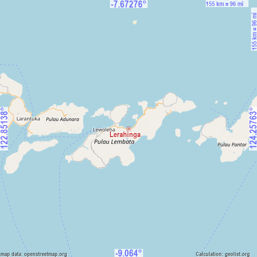
Lerahinga GPS coordinates[2]
8° 22' 8.4" South, 123° 33' 16.2" East
| Map corner | latitude | longitude |
|---|---|---|
| Upper-left | -7.67276°, | 122.85138° |
| Center: | -8.369°, | 123.5545° |
| Lower-right: | -9.064°, | 124.25763° |
| Map W x H: | 154.7×154.7 km | = 96.1×96.1mi |
| max Lat: | 5.88969° ⇑79.4% North |
| Lerahinga: | -8.369° |
| min Lat: | ⇓20.6% South -10.934° |
| min Long | Lerahinga | max Long |
| 95.1345° | 123.5545° | 140.9419° |
| W 92.6%⇐ | ⇒7.4% E |
Elevation
Elevation of Lerahinga is 22 m = 72 ft, and this is 207.7 m = 681 ft below average elevation for this country.
| Max E: |
3185 m = 10449 ft | 77.1% |
| Avg. | 229.7 m = 754 ft | |
| Lerahinga | 22 m = 72 ft | |
Min E: |
-1 m = -3 ft | 22.9% |
See also: Indonesia elevation on elevation.city.
Geographical zone
Lerahinga is located in South Torrid zone (between Equator and Tropic of Capricorn). Distance of Equator is 930.5 km =578.2 mi to North.| Distance of | km | miles | from Lerahinga |
|---|---|---|---|
| Equator | 930.5 | 578.2 | to North |
| Tropic Capricorn | 1675.4 | 1041 | to South |
| Antarctic Circle | 6470.6 | 4020.6 | to South |
| South Pole | 9076.5 | 5639.9 | to South |


Nearby cities:
15 places around Lerahinga: (largest is in red/bold)
• Baopukang
7.8 km =4.8 mi,  329°
329°
• Hadakewa
0.8 km =0.5 mi,  263°
263°
• Karangora
10.1 km =6.3 mi,  210°
210°
• Kimakamak
7.1 km =4.4 mi,  303°
303°
• Lamatuka
6.4 km =4 mi,  274°
274°
• Lamawolo
11.3 km =7 mi,  355°
355°
• Leramatang
2 km =1.2 mi,  75°
75°
• Lewodoli
11.2 km =7 mi, 78°
• Lewoeleng
8.7 km =5.4 mi,  65°
65°
• Lodobelolong
10.3 km =6.4 mi, 69°
• Merdeka
3.1 km =1.9 mi,  276°
276°
• Muruona
9.6 km =6 mi, 297°
• Tanakereket
5.9 km =3.7 mi, 278°
• Tapolangu
9.9 km =6.2 mi,  45°
45°
• Waipukang
11.3 km =7 mi, 298°
Sources, notices
• [Note1] Compared only with cities in Indonesia existing in our database
• [Src1] Map data: © OpenStreetMap contributors (CC-BY-SA)
• [Src2] Other city data from geonames.org with taken over terms of usage.
• [Src3] Geographical zone / Annual Mean Temperature by Robert A. Rohde @ Wikipedia
