Laka geodata
Laka (East Nusa Tenggara) is a seat of a fourth-order administrative division; located in Indonesia in Asia/Makassar (GMT+8) time zone. In our database, there are 407 cities with bigger population. Compared to other cities in Indonesia, 69.2% of cities are located further ↑North; 90% of cities are located further ←West and 86.4% of cities have higher elevation than Laka. Note1


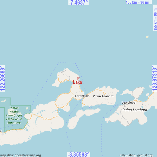
Laka GPS coordinates[2]
8° 9' 37.08" South, 122° 58' 12" East
| Map corner | latitude | longitude |
|---|---|---|
| Upper-left | -7.4637°, | 122.26688° |
| Center: | -8.1603°, | 122.97° |
| Lower-right: | -8.85568°, | 123.67313° |
| Map W x H: | 154.8×154.8 km | = 96.2×96.2mi |
| max Lat: | 5.88969° ⇑69.2% North |
| Laka: | -8.1603° |
| min Lat: | ⇓30.8% South -10.934° |
| min Long | Laka | max Long |
| 95.1345° | 122.97° | 140.9419° |
| W 90%⇐ | ⇒10% E |
Elevation
Elevation of Laka is 13 m = 43 ft, and this is 216.7 m = 711 ft below average elevation for this country.
| Max E: |
3185 m = 10449 ft | 86.4% |
| Avg. | 229.7 m = 754 ft | |
| Laka | 13 m = 43 ft | |
Min E: |
-1 m = -3 ft | 13.6% |
See also: Indonesia elevation on elevation.city.
Geographical zone
Laka is located in South Torrid zone (between Equator and Tropic of Capricorn). Distance of Equator is 907.3 km =563.8 mi to North.| Distance of | km | miles | from Laka |
|---|---|---|---|
| Equator | 907.3 | 563.8 | to North |
| Tropic Capricorn | 1698.6 | 1055.5 | to South |
| Antarctic Circle | 6493.8 | 4035.1 | to South |
| South Pole | 9099.7 | 5654.3 | to South |


Nearby cities:
15 places around Laka: (largest is in red/bold)
• Basira Satu
15.9 km =9.9 mi,  304°
304°
• Bedalewun
16.3 km =10.1 mi,  258°
258°
• Belogili
7.5 km =4.7 mi,  223°
223°
• Ebak
13.2 km =8.2 mi,  265°
265°
• Kawaliwu
14.9 km =9.3 mi,  213°
213°
• Koten
16.5 km =10.3 mi,  294°
294°
• Lamatou
14.9 km =9.3 mi,  198°
198°
• Lewohala
13.8 km =8.6 mi,  187°
187°
• Lewotola
15.6 km =9.7 mi, 200°
• Riangkoli
5.4 km =3.4 mi,  234°
234°
• Riangpedang
17.6 km =10.9 mi, 214°
• Waiklibang
8.4 km =5.2 mi, 259°
• Waimana Satu
10.1 km =6.3 mi,  173°
173°
• Watotenga
14.4 km =8.9 mi, 190°
• Watowiti
13.3 km =8.3 mi, 165°
Sources, notices
• [Note1] Compared only with cities in Indonesia existing in our database
• [Src1] Map data: © OpenStreetMap contributors (CC-BY-SA)
• [Src2] Other city data from geonames.org with taken over terms of usage.
• [Src3] Geographical zone / Annual Mean Temperature by Robert A. Rohde @ Wikipedia
