Mangge geodata
Mangge (West Nusa Tenggara) is a seat of a fourth-order administrative division; located in Indonesia in Asia/Makassar (GMT+8) time zone. In our database, there are 407 cities with bigger population. Compared to other cities in Indonesia, 88.7% of cities are located further ↑North; 80.6% of cities are located further ←West and 55.6% of cities have higher elevation than Mangge. Note1


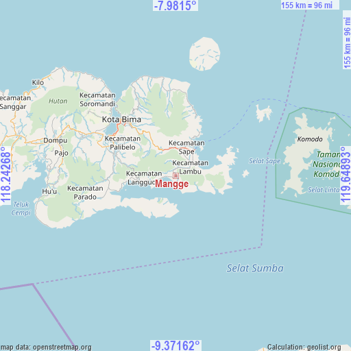
Mangge GPS coordinates[2]
8° 40' 37.92" South, 118° 56' 44.88" East
| Map corner | latitude | longitude |
|---|---|---|
| Upper-left | -7.9815°, | 118.24268° |
| Center: | -8.6772°, | 118.9458° |
| Lower-right: | -9.37162°, | 119.64893° |
| Map W x H: | 154.6×154.6 km | = 96.1×96.1mi |
| max Lat: | 5.88969° ⇑88.7% North |
| Mangge: | -8.6772° |
| min Lat: | ⇓11.3% South -10.934° |
| min Long | Mangge | max Long |
| 95.1345° | 118.9458° | 140.9419° |
| W 80.6%⇐ | ⇒19.4% E |
Elevation
Elevation of Mangge is 81 m = 266 ft, and this is 148.7 m = 488 ft below average elevation for this country.
| Max E: |
3185 m = 10449 ft | 55.6% |
| Avg. | 229.7 m = 754 ft | |
| Mangge | 81 m = 266 ft | |
Min E: |
-1 m = -3 ft | 44.4% |
See also: Indonesia elevation on elevation.city.
Geographical zone
Mangge is located in South Torrid zone (between Equator and Tropic of Capricorn). Distance of Equator is 964.8 km =599.5 mi to North.| Distance of | km | miles | from Mangge |
|---|---|---|---|
| Equator | 964.8 | 599.5 | to North |
| Tropic Capricorn | 1641.1 | 1019.7 | to South |
| Antarctic Circle | 6436.4 | 3999.4 | to South |
| South Pole | 9042.2 | 5618.6 | to South |


Nearby cities:
15 places around Mangge: (largest is in red/bold)
• Balai
9.6 km =6 mi,  25°
25°
• Bau
13.1 km =8.1 mi,  12°
12°
• Bombo
10.3 km =6.4 mi,  46°
46°
• Kalede
12.6 km =7.8 mi,  21°
21°
• Kalodu
12 km =7.5 mi,  279°
279°
• Karumbu
12.8 km =8 mi,  261°
261°
• Lanta Timur
8.8 km =5.5 mi,  41°
41°
• Melati
12.5 km =7.8 mi,  350°
350°
• Naebugis
13 km =8.1 mi, 31°
• Naru
12.8 km =8 mi, 23°
• Rupe
12 km =7.5 mi, 260°
• Sape
13 km =8.1 mi, 18°
• Sigirato
9.8 km =6.1 mi, 48°
• Sukamaju
11.9 km =7.4 mi, 14°
• Wadusari
12.2 km =7.6 mi,  340°
340°
Sources, notices
• [Note1] Compared only with cities in Indonesia existing in our database
• [Src1] Map data: © OpenStreetMap contributors (CC-BY-SA)
• [Src2] Other city data from geonames.org with taken over terms of usage.
• [Src3] Geographical zone / Annual Mean Temperature by Robert A. Rohde @ Wikipedia
