Sape geodata
Sape is a populated place; located in Indonesia in Asia/Makassar (GMT+8) time zone. With population of 5,000 people, there are 386 cities with bigger population in this country. Compared to other cities in Indonesia, 86% of cities are located further ↑North; 80.7% of cities are located further ←West and 73.4% of cities have higher elevation than Sape. Note1


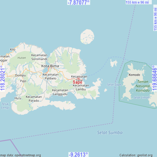
Sape GPS coordinates[2]
8° 34' 0.012" South, 118° 58' 59.988" East
| Map corner | latitude | longitude |
|---|---|---|
| Upper-left | -7.87077°, | 118.28021° |
| Center: | -8.56667°, | 118.98333° |
| Lower-right: | -9.2613°, | 119.68646° |
| Map W x H: | 154.6×154.6 km | = 96.1×96.1mi |
| max Lat: | 5.88969° ⇑86% North |
| Sape: | -8.56667° |
| min Lat: | ⇓14% South -10.934° |
| min Long | Sape | max Long |
| 95.1345° | 118.98333° | 140.9419° |
| W 80.7%⇐ | ⇒19.3% E |
Elevation
Elevation of Sape is 27 m = 89 ft, and this is 202.7 m = 665 ft below average elevation for this country.
| Max E: |
3185 m = 10449 ft | 73.4% |
| Avg. | 229.7 m = 754 ft | |
| Sape | 27 m = 89 ft | |
Min E: |
-1 m = -3 ft | 26.6% |
See also: Indonesia elevation on elevation.city.
Geographical zone
Sape is located in South Torrid zone (between Equator and Tropic of Capricorn). Distance of Equator is 952.5 km =591.9 mi to North.| Distance of | km | miles | from Sape |
|---|---|---|---|
| Equator | 952.5 | 591.9 | to North |
| Tropic Capricorn | 1653.4 | 1027.4 | to South |
| Antarctic Circle | 6448.6 | 4007 | to South |
| South Pole | 9054.5 | 5626.2 | to South |


Nearby cities:
15 places around Sape: (largest is in red/bold)
• Balai
3.6 km =2.2 mi,  181°
181°
• Bau
1.3 km =0.8 mi,  290°
290°
• Bombo
6.1 km =3.8 mi,  147°
147°
• Kalede
0.7 km =0.4 mi,  138°
138°
• Kowo
4.3 km =2.7 mi,  35°
35°
• Lanta Timur
6 km =3.7 mi,  162°
162°
• Melati
6.1 km =3.8 mi,  270°
270°
• Nae
0.3 km =0.2 mi,  320°
320°
• Naebugis
2.9 km =1.8 mi,  114°
114°
• Naru
1.2 km =0.7 mi,  119°
119°
• Pataha
5 km =3.1 mi,  34°
34°
• Raioi
0.6 km =0.4 mi,  311°
311°
• Rasabau
0.1 km =0.1 mi,  67°
67°
• Sangia
0.4 km =0.2 mi,  4°
4°
• Sukamaju
1.4 km =0.9 mi,  237°
237°
Sources, notices
• [Note1] Compared only with cities in Indonesia existing in our database
• [Src1] Map data: © OpenStreetMap contributors (CC-BY-SA)
• [Src2] Other city data from geonames.org with taken over terms of usage.
• [Src3] Geographical zone / Annual Mean Temperature by Robert A. Rohde @ Wikipedia
