Kore Barat geodata
Kore Barat (West Nusa Tenggara) is a seat of a fourth-order administrative division; located in Indonesia in Asia/Makassar (GMT+8) time zone. In our database, there are 407 cities with bigger population. Compared to other cities in Indonesia, 79.6% of cities are located further ↑North; 79.5% of cities are located further ←West and 80.9% of cities have higher elevation than Kore Barat. Note1


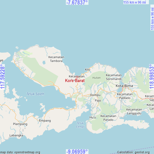
Kore Barat GPS coordinates[2]
8° 22' 28.56" South, 118° 17' 43.44" East
| Map corner | latitude | longitude |
|---|---|---|
| Upper-left | -7.67837°, | 117.59228° |
| Center: | -8.3746°, | 118.2954° |
| Lower-right: | -9.06959°, | 118.99853° |
| Map W x H: | 154.7×154.7 km | = 96.1×96.1mi |
| max Lat: | 5.88969° ⇑79.6% North |
| Kore Barat: | -8.3746° |
| min Lat: | ⇓20.4% South -10.934° |
| min Long | Kore Barat | max Long |
| 95.1345° | 118.2954° | 140.9419° |
| W 79.5%⇐ | ⇒20.5% E |
Elevation
Elevation of Kore Barat is 18 m = 59 ft, and this is 211.7 m = 695 ft below average elevation for this country.
| Max E: |
3185 m = 10449 ft | 80.9% |
| Avg. | 229.7 m = 754 ft | |
| Kore Barat | 18 m = 59 ft | |
Min E: |
-1 m = -3 ft | 19.1% |
See also: Indonesia elevation on elevation.city.
Geographical zone
Kore Barat is located in South Torrid zone (between Equator and Tropic of Capricorn). Distance of Equator is 931.2 km =578.6 mi to North.| Distance of | km | miles | from Kore Barat |
|---|---|---|---|
| Equator | 931.2 | 578.6 | to North |
| Tropic Capricorn | 1674.8 | 1040.7 | to South |
| Antarctic Circle | 6470 | 4020.3 | to South |
| South Pole | 9075.9 | 5639.5 | to South |


Nearby cities:
15 places around Kore Barat: (largest is in red/bold)
• Boro
2.2 km =1.4 mi,  287°
287°
• Kalate
19.4 km =12.1 mi,  195°
195°
• Kambu
3.1 km =1.9 mi,  114°
114°
• Kore
0.4 km =0.2 mi, 112°
• Lanci Satu
13.4 km =8.3 mi,  169°
169°
• Lasi Dua
14.3 km =8.9 mi,  55°
55°
• Malaju
13 km =8.1 mi, 56°
• Nusajaya
12 km =7.5 mi, 174°
• Pali
1.5 km =0.9 mi,  97°
97°
• Piong
4.9 km =3 mi, 293°
• Rasabou
18.6 km =11.6 mi,  193°
193°
• Samangawah
13.4 km =8.3 mi,  178°
178°
• Soriutu
16.3 km =10.1 mi, 169°
• Sumur Lima
13.3 km =8.3 mi, 178°
• Taloko
3.8 km =2.4 mi,  141°
141°
Sources, notices
• [Note1] Compared only with cities in Indonesia existing in our database
• [Src1] Map data: © OpenStreetMap contributors (CC-BY-SA)
• [Src2] Other city data from geonames.org with taken over terms of usage.
• [Src3] Geographical zone / Annual Mean Temperature by Robert A. Rohde @ Wikipedia
