Konkokon geodata
Konkokon (East Java) is a seat of a fourth-order administrative division; located in Indonesia in Asia/Jakarta (GMT+7) time zone. In our database, there are 407 cities with bigger population. Compared to other cities in Indonesia, 63.5% of cities are located further ↓South; 64.3% of cities are located further ←West and 53.4% of cities have lower elevation than Konkokon. Note1


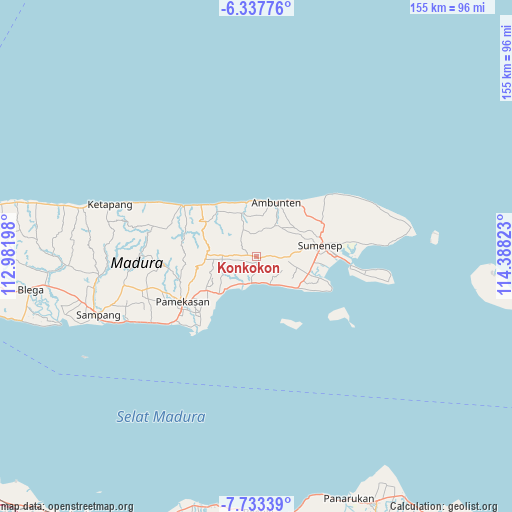
Konkokon GPS coordinates[2]
7° 2' 9.96" South, 113° 41' 6.36" East
| Map corner | latitude | longitude |
|---|---|---|
| Upper-left | -6.33776°, | 112.98198° |
| Center: | -7.0361°, | 113.6851° |
| Lower-right: | -7.73339°, | 114.38823° |
| Map W x H: | 155.2×155.2 km | = 96.4×96.4mi |
| max Lat: | 5.88969° ⇑36.5% North |
| Konkokon: | -7.0361° |
| min Lat: | ⇓63.5% South -10.934° |
| min Long | Konkokon | max Long |
| 95.1345° | 113.6851° | 140.9419° |
| W 64.3%⇐ | ⇒35.7% E |
Elevation
Elevation of Konkokon is 116 m = 381 ft, and this is 113.7 m = 373 ft below average elevation for this country.
| Max E: |
3185 m = 10449 ft | 46.6% |
| Avg. | 229.7 m = 754 ft | |
| Konkokon | 116 m = 381 ft | |
Min E: |
-1 m = -3 ft | 53.4% |
See also: Indonesia elevation on elevation.city.
Geographical zone
Konkokon is located in South Torrid zone (between Equator and Tropic of Capricorn). Distance of Equator is 782.3 km =486.1 mi to North.| Distance of | km | miles | from Konkokon |
|---|---|---|---|
| Equator | 782.3 | 486.1 | to North |
| Tropic Capricorn | 1823.6 | 1133.1 | to South |
| Antarctic Circle | 6618.8 | 4112.7 | to South |
| South Pole | 9224.7 | 5732 | to South |


Nearby cities:
15 places around Konkokon: (largest is in red/bold)
• Banlapa
2.8 km =1.7 mi,  276°
276°
• Dajalorong
4.2 km =2.6 mi,  131°
131°
• Duko
1.5 km =0.9 mi,  163°
163°
• Ganding
0.5 km =0.3 mi, 126°
• Gulukguluk
2.3 km =1.4 mi,  207°
207°
• Karangjati
4.5 km =2.8 mi,  113°
113°
• Kebunan
3.2 km =2 mi, 128°
• Loaksongai
5 km =3.1 mi, 108°
• Mangar
4.4 km =2.7 mi,  57°
57°
• Masjid
0.6 km =0.4 mi,  166°
166°
• Naga
1.3 km =0.8 mi, 134°
• Panggungdaja
2.1 km =1.3 mi, 155°
• Sumberkindagan
2.9 km =1.8 mi, 172°
• Talambung Laok
1.9 km =1.2 mi,  97°
97°
• Timurleke
1 km =0.6 mi,  263°
263°
Sources, notices
• [Note1] Compared only with cities in Indonesia existing in our database
• [Src1] Map data: © OpenStreetMap contributors (CC-BY-SA)
• [Src2] Other city data from geonames.org with taken over terms of usage.
• [Src3] Geographical zone / Annual Mean Temperature by Robert A. Rohde @ Wikipedia
