Gapurana Daya geodata
Gapurana Daya (East Java) is a seat of a fourth-order administrative division; located in Indonesia in Asia/Jakarta (GMT+7) time zone. In our database, there are 407 cities with bigger population. Compared to other cities in Indonesia, 61.3% of cities are located further ↓South; 67.1% of cities are located further ←West and 89% of cities have higher elevation than Gapurana Daya. Note1


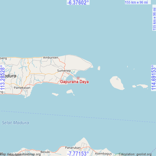
Gapurana Daya GPS coordinates[2]
7° 4' 27.48" South, 113° 59' 18.24" East
| Map corner | latitude | longitude |
|---|---|---|
| Upper-left | -6.37602°, | 113.28528° |
| Center: | -7.0743°, | 113.9884° |
| Lower-right: | -7.77153°, | 114.69153° |
| Map W x H: | 155.2×155.2 km | = 96.4×96.4mi |
| max Lat: | 5.88969° ⇑38.7% North |
| Gapurana Daya: | -7.0743° |
| min Lat: | ⇓61.3% South -10.934° |
| min Long | Gapurana Daya | max Long |
| 95.1345° | 113.9884° | 140.9419° |
| W 67.1%⇐ | ⇒32.9% E |
Elevation
Elevation of Gapurana Daya is 11 m = 36 ft, and this is 218.7 m = 718 ft below average elevation for this country.
| Max E: |
3185 m = 10449 ft | 89% |
| Avg. | 229.7 m = 754 ft | |
| Gapurana Daya | 11 m = 36 ft | |
Min E: |
-1 m = -3 ft | 11% |
See also: Indonesia elevation on elevation.city.
Geographical zone
Gapurana Daya is located in South Torrid zone (between Equator and Tropic of Capricorn). Distance of Equator is 786.6 km =488.8 mi to North.| Distance of | km | miles | from Gapurana Daya |
|---|---|---|---|
| Equator | 786.6 | 488.8 | to North |
| Tropic Capricorn | 1819.3 | 1130.5 | to South |
| Antarctic Circle | 6614.6 | 4110.1 | to South |
| South Pole | 9220.5 | 5729.4 | to South |


Nearby cities:
15 places around Gapurana Daya: (largest is in red/bold)
• Banjeru
8.8 km =5.5 mi,  341°
341°
• Darmaayu
8.4 km =5.2 mi,  348°
348°
• Galtek
4.5 km =2.8 mi,  87°
87°
• Gersikputih Tengah
5.6 km =3.5 mi,  320°
320°
• Girsereng
8.7 km =5.4 mi,  30°
30°
• Kalianget
5.6 km =3.5 mi,  294°
294°
• Karengan
3.3 km =2.1 mi,  282°
282°
• Kebunkelapa
7.5 km =4.7 mi,  297°
297°
• Mandala
8.5 km =5.3 mi, 345°
• Padurekso
5.9 km =3.7 mi, 299°
• Polay
8.8 km =5.5 mi,  9°
9°
• Sumurasin
5.4 km =3.4 mi,  267°
267°
• Talaga
6.7 km =4.2 mi,  120°
120°
• Talango
4.3 km =2.7 mi, 286°
• Taman
5.9 km =3.7 mi, 90°
Sources, notices
• [Note1] Compared only with cities in Indonesia existing in our database
• [Src1] Map data: © OpenStreetMap contributors (CC-BY-SA)
• [Src2] Other city data from geonames.org with taken over terms of usage.
• [Src3] Geographical zone / Annual Mean Temperature by Robert A. Rohde @ Wikipedia
