Talaga geodata
Talaga (East Java) is a seat of a fourth-order administrative division; located in Indonesia in Asia/Jakarta (GMT+7) time zone. In our database, there are 407 cities with bigger population. Compared to other cities in Indonesia, 59.9% of cities are located further ↓South; 67.5% of cities are located further ←West and 53% of cities have higher elevation than Talaga. Note1


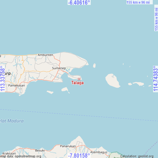
Talaga GPS coordinates[2]
7° 6' 15.84" South, 114° 2' 26.52" East
| Map corner | latitude | longitude |
|---|---|---|
| Upper-left | -6.40616°, | 113.33758° |
| Center: | -7.1044°, | 114.0407° |
| Lower-right: | -7.80158°, | 114.74383° |
| Map W x H: | 155.2×155.2 km | = 96.4×96.4mi |
| max Lat: | 5.88969° ⇑40.1% North |
| Talaga: | -7.1044° |
| min Lat: | ⇓59.9% South -10.934° |
| min Long | Talaga | max Long |
| 95.1345° | 114.0407° | 140.9419° |
| W 67.5%⇐ | ⇒32.5% E |
Elevation
Elevation of Talaga is 92 m = 302 ft, and this is 137.7 m = 452 ft below average elevation for this country.
| Max E: |
3185 m = 10449 ft | 53% |
| Avg. | 229.7 m = 754 ft | |
| Talaga | 92 m = 302 ft | |
Min E: |
-1 m = -3 ft | 47% |
See also: Indonesia elevation on elevation.city.
Geographical zone
Talaga is located in South Torrid zone (between Equator and Tropic of Capricorn). Distance of Equator is 789.9 km =490.8 mi to North.| Distance of | km | miles | from Talaga |
|---|---|---|---|
| Equator | 789.9 | 490.8 | to North |
| Tropic Capricorn | 1816 | 1128.4 | to South |
| Antarctic Circle | 6611.2 | 4108 | to South |
| South Pole | 9217.1 | 5727.2 | to South |


Nearby cities:
15 places around Talaga: (largest is in red/bold)
• Budagan
14 km =8.7 mi,  18°
18°
• Darmaayu
13.8 km =8.6 mi,  327°
327°
• Galtek
3.7 km =2.3 mi,  340°
340°
• Gapurana Daya
6.7 km =4.2 mi,  300°
300°
• Gersikputih Tengah
12.1 km =7.5 mi,  309°
309°
• Girsereng
11 km =6.8 mi,  352°
352°
• Kalianget
12.2 km =7.6 mi, 297°
• Karengan
9.9 km =6.2 mi,  294°
294°
• Padurekso
12.5 km =7.8 mi, 299°
• Patandun
12 km =7.5 mi,  6°
6°
• Polay
12.8 km =8 mi, 340°
• Somorpenang
12.4 km =7.7 mi, 10°
• Sumurasin
11.5 km =7.1 mi, 285°
• Talango
10.9 km =6.8 mi, 294°
• Taman
3.3 km =2.1 mi,  2°
2°
Sources, notices
• [Note1] Compared only with cities in Indonesia existing in our database
• [Src1] Map data: © OpenStreetMap contributors (CC-BY-SA)
• [Src2] Other city data from geonames.org with taken over terms of usage.
• [Src3] Geographical zone / Annual Mean Temperature by Robert A. Rohde @ Wikipedia
