Tapintengah geodata
Tapintengah (South Kalimantan) is a seat of a third-order administrative division; located in Indonesia in Asia/Makassar (GMT+8) time zone. In our database, there are 407 cities with bigger population. Compared to other cities in Indonesia, 91.3% of cities are located further ↓South; 71% of cities are located further ←West and 99.1% of cities have higher elevation than Tapintengah. Note1


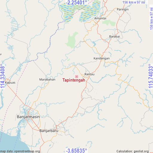
Tapintengah GPS coordinates[2]
2° 57' 23.04" South, 115° 2' 13.92" East
| Map corner | latitude | longitude |
|---|---|---|
| Upper-left | -2.25401°, | 114.33408° |
| Center: | -2.9564°, | 115.0372° |
| Lower-right: | -3.65835°, | 115.74033° |
| Map W x H: | 156.1×156.2 km | = 97×97.1mi |
| max Lat: | 5.88969° ⇑8.7% North |
| Tapintengah: | -2.9564° |
| min Lat: | ⇓91.3% South -10.934° |
| min Long | Tapintengah | max Long |
| 95.1345° | 115.0372° | 140.9419° |
| W 71%⇐ | ⇒29% E |
Elevation
Elevation of Tapintengah is 4 m = 13 ft, and this is 225.7 m = 740 ft below average elevation for this country.
| Max E: |
3185 m = 10449 ft | 99.1% |
| Avg. | 229.7 m = 754 ft | |
| Tapintengah | 4 m = 13 ft | |
Min E: |
-1 m = -3 ft | 0.9% |
See also: Indonesia elevation on elevation.city.
Geographical zone
Tapintengah is located in South Torrid zone (between Equator and Tropic of Capricorn). Distance of Equator is 328.7 km =204.2 mi to North.| Distance of | km | miles | from Tapintengah |
|---|---|---|---|
| Equator | 328.7 | 204.2 | to North |
| Tropic Capricorn | 2277.2 | 1415 | to South |
| Antarctic Circle | 7072.5 | 4394.6 | to South |
| South Pole | 9678.3 | 6013.8 | to South |


Nearby cities:
15 places around Tapintengah: (largest is in red/bold)
• Bantul
32.1 km =19.9 mi,  252°
252°
• Belimbing
34.9 km =21.7 mi,  94°
94°
• Binuang
19 km =11.8 mi,  132°
132°
• Kandangan
32.8 km =20.4 mi,  54°
54°
• Marabahan
30.5 km =19 mi,  257°
257°
• Margasari
11.2 km =7 mi,  359°
359°
• Margasarihilir
14.8 km =9.2 mi,  346°
346°
• Padangbatung
31.1 km =19.3 mi,  64°
64°
• Pasingkan
35.7 km =22.2 mi,  32°
32°
• Rantau
14.1 km =8.8 mi,  79°
79°
• Simpangempat
35.8 km =22.2 mi,  181°
181°
• Simpur
29.2 km =18.1 mi, 60°
• Sungairaya
25.8 km =16 mi, 64°
• Sungairaya
36.8 km =22.9 mi, 176°
• Tambarangan
11.8 km =7.3 mi,  116°
116°
Sources, notices
• [Note1] Compared only with cities in Indonesia existing in our database
• [Src1] Map data: © OpenStreetMap contributors (CC-BY-SA)
• [Src2] Other city data from geonames.org with taken over terms of usage.
• [Src3] Geographical zone / Annual Mean Temperature by Robert A. Rohde @ Wikipedia
