Sungairaya geodata
Sungairaya (South Kalimantan) is a seat of a third-order administrative division; located in Indonesia in Asia/Makassar (GMT+8) time zone. In our database, there are 407 cities with bigger population. Compared to other cities in Indonesia, 91.6% of cities are located further ↓South; 73% of cities are located further ←West and 60.6% of cities have higher elevation than Sungairaya. Note1


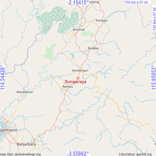
Sungairaya GPS coordinates[2]
2° 51' 23.76" South, 115° 14' 50.64" East
| Map corner | latitude | longitude |
|---|---|---|
| Upper-left | -2.15415°, | 114.54428° |
| Center: | -2.8566°, | 115.2474° |
| Lower-right: | -3.55862°, | 115.95053° |
| Map W x H: | 156.2×156.2 km | = 97.1×97.1mi |
| max Lat: | 5.88969° ⇑8.4% North |
| Sungairaya: | -2.8566° |
| min Lat: | ⇓91.6% South -10.934° |
| min Long | Sungairaya | max Long |
| 95.1345° | 115.2474° | 140.9419° |
| W 73%⇐ | ⇒27% E |
Elevation
Elevation of Sungairaya is 57 m = 187 ft, and this is 172.7 m = 567 ft below average elevation for this country.
| Max E: |
3185 m = 10449 ft | 60.6% |
| Avg. | 229.7 m = 754 ft | |
| Sungairaya | 57 m = 187 ft | |
Min E: |
-1 m = -3 ft | 39.4% |
See also: Indonesia elevation on elevation.city.
Geographical zone
Sungairaya is located in South Torrid zone (between Equator and Tropic of Capricorn). Distance of Equator is 317.6 km =197.3 mi to North.| Distance of | km | miles | from Sungairaya |
|---|---|---|---|
| Equator | 317.6 | 197.3 | to North |
| Tropic Capricorn | 2288.3 | 1421.9 | to South |
| Antarctic Circle | 7083.5 | 4401.5 | to South |
| South Pole | 9689.4 | 6020.7 | to South |


Nearby cities:
15 places around Sungairaya: (largest is in red/bold)
• Angkimang
15.3 km =9.5 mi,  27°
27°
• Barikin
21.5 km =13.4 mi,  23°
23°
• Belimbing
18 km =11.2 mi,  140°
140°
• Binuang
25.6 km =15.9 mi,  201°
201°
• Haruyan
21.6 km =13.4 mi, 31°
• Kandangan
8.8 km =5.5 mi, 22°
• Loklaga
21.2 km =13.2 mi,  40°
40°
• Margasari
23.4 km =14.5 mi,  270°
270°
• Padangbatung
5.3 km =3.3 mi,  66°
66°
• Pantaihambawang
25.1 km =15.6 mi, 21°
• Pasingkan
19.4 km =12.1 mi,  347°
347°
• Rantau
12.8 km =8 mi,  227°
227°
• Simpur
3.8 km =2.4 mi, 33°
• Tambarangan
20.8 km =12.9 mi,  218°
218°
• Tapintengah
25.8 km =16 mi,  244°
244°
Sources, notices
• [Note1] Compared only with cities in Indonesia existing in our database
• [Src1] Map data: © OpenStreetMap contributors (CC-BY-SA)
• [Src2] Other city data from geonames.org with taken over terms of usage.
• [Src3] Geographical zone / Annual Mean Temperature by Robert A. Rohde @ Wikipedia
