Mangupura geodata
Mangupura (Bali) is a seat of a second-order administrative division; located in Indonesia in Asia/Makassar (GMT+8) time zone. In our database, there are 407 cities with bigger population. Compared to other cities in Indonesia, 85.1% of cities are located further ↑North; 72.3% of cities are located further ←West and 55.4% of cities have lower elevation than Mangupura. Note1


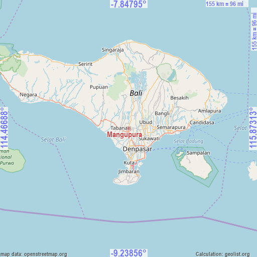
Mangupura GPS coordinates[2]
8° 32' 38.004" South, 115° 10' 12" East
| Map corner | latitude | longitude |
|---|---|---|
| Upper-left | -7.84795°, | 114.46688° |
| Center: | -8.54389°, | 115.17° |
| Lower-right: | -9.23856°, | 115.87313° |
| Map W x H: | 154.6×154.6 km | = 96.1×96.1mi |
| max Lat: | 5.88969° ⇑85.1% North |
| Mangupura: | -8.54389° |
| min Lat: | ⇓14.9% South -10.934° |
| min Long | Mangupura | max Long |
| 95.1345° | 115.17° | 140.9419° |
| W 72.3%⇐ | ⇒27.7% E |
Elevation
Elevation of Mangupura is 127 m = 417 ft, and this is 102.7 m = 337 ft below average elevation for this country.
| Max E: |
3185 m = 10449 ft | 44.6% |
| Avg. | 229.7 m = 754 ft | |
| Mangupura | 127 m = 417 ft | |
Min E: |
-1 m = -3 ft | 55.4% |
See also: Indonesia elevation on elevation.city.
Geographical zone
Mangupura is located in South Torrid zone (between Equator and Tropic of Capricorn). Distance of Equator is 950 km =590.3 mi to North.| Distance of | km | miles | from Mangupura |
|---|---|---|---|
| Equator | 950 | 590.3 | to North |
| Tropic Capricorn | 1655.9 | 1028.9 | to South |
| Antarctic Circle | 6451.2 | 4008.6 | to South |
| South Pole | 9057.1 | 5627.8 | to South |


Nearby cities:
15 places around Mangupura: (largest is in red/bold)
• Banjar Abiantuwung
2.8 km =1.7 mi,  236°
236°
• Banjar Banjaranyar
2.8 km =1.7 mi,  266°
266°
• Banjar Batanyuh Kaja
4 km =2.5 mi,  356°
356°
• Banjar Cemenggon
3.3 km =2.1 mi,  80°
80°
• Banjar Danginpangkung
3.6 km =2.2 mi,  189°
189°
• Banjar Jagasatru
3.9 km =2.4 mi, 240°
• Banjar Jumbayah
2.4 km =1.5 mi, 191°
• Banjar Kedua
3.4 km =2.1 mi,  32°
32°
• Banjar Lebahsari
0.6 km =0.4 mi,  104°
104°
• Banjar Pekenjelodan
3.6 km =2.2 mi,  166°
166°
• Banjar Puseh
4.3 km =2.7 mi, 236°
• Banjar Sayanbaleran
4.4 km =2.7 mi,  15°
15°
• Banjar Sempidi
4.5 km =2.8 mi,  59°
59°
• Banjar Serangan
0.1 km =0.1 mi,  48°
48°
• Banjar Tengahbelayu
3.3 km =2.1 mi,  354°
354°
Sources, notices
• [Note1] Compared only with cities in Indonesia existing in our database
• [Src1] Map data: © OpenStreetMap contributors (CC-BY-SA)
• [Src2] Other city data from geonames.org with taken over terms of usage.
• [Src3] Geographical zone / Annual Mean Temperature by Robert A. Rohde @ Wikipedia
