Banjar Tengahbelayu geodata
Banjar Tengahbelayu (Bali) is a seat of a fourth-order administrative division; located in Indonesia in Asia/Makassar (GMT+8) time zone. In our database, there are 407 cities with bigger population. Compared to other cities in Indonesia, 84% of cities are located further ↑North; 72.2% of cities are located further ←West and 61.2% of cities have lower elevation than Banjar Tengahbelayu. Note1


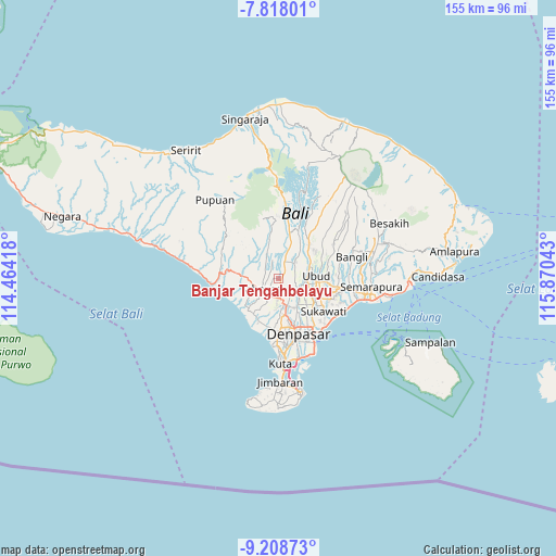
Banjar Tengahbelayu GPS coordinates[2]
8° 30' 50.4" South, 115° 10' 2.28" East
| Map corner | latitude | longitude |
|---|---|---|
| Upper-left | -7.81801°, | 114.46418° |
| Center: | -8.514°, | 115.1673° |
| Lower-right: | -9.20873°, | 115.87043° |
| Map W x H: | 154.6×154.6 km | = 96.1×96.1mi |
| max Lat: | 5.88969° ⇑84% North |
| Banjar Tengahbelayu: | -8.514° |
| min Lat: | ⇓16% South -10.934° |
| min Long | Banjar Tengahbe | max Long |
| 95.1345° | 115.1673° | 140.9419° |
| W 72.2%⇐ | ⇒27.8% E |
Elevation
Elevation of Banjar Tengahbelayu is 177 m = 581 ft, and this is 52.7 m = 173 ft below average elevation for this country.
| Max E: |
3185 m = 10449 ft | 38.8% |
| Avg. | 229.7 m = 754 ft | |
| Banjar Tengahbelayu | 177 m = 581 ft | |
Min E: |
-1 m = -3 ft | 61.2% |
See also: Indonesia elevation on elevation.city.
Geographical zone
Banjar Tengahbelayu is located in South Torrid zone (between Equator and Tropic of Capricorn). Distance of Equator is 946.7 km =588.3 mi to North.| Distance of | km | miles | from Banjar Tengahbelayu |
|---|---|---|---|
| Equator | 946.7 | 588.3 | to North |
| Tropic Capricorn | 1659.3 | 1031 | to South |
| Antarctic Circle | 6454.5 | 4010.6 | to South |
| South Pole | 9060.4 | 5629.9 | to South |


Nearby cities:
15 places around Banjar Tengahbelayu: (largest is in red/bold)
• Banjar Badung Tengah
3.6 km =2.2 mi,  77°
77°
• Banjar Banjaranyar
4.3 km =2.7 mi,  215°
215°
• Banjar Batanyuh Kaja
0.7 km =0.4 mi,  4°
4°
• Banjar Kedua
2.2 km =1.4 mi,  103°
103°
• Banjar Lebahsari
3.6 km =2.2 mi,  165°
165°
• Banjar Sayanbaleran
1.7 km =1.1 mi,  58°
58°
• Banjar Serangan
3.3 km =2.1 mi, 173°
• Banjar Tengah
3.4 km =2.1 mi, 59°
• Banjar Tuakilangbaleran
4.3 km =2.7 mi,  261°
261°
• Basa
4.4 km =2.7 mi, 1°
• Buahan Tengah
2.9 km =1.8 mi,  317°
317°
• Kekeran
2.8 km =1.7 mi,  23°
23°
• Kuwumkumambal
2.9 km =1.8 mi, 4°
• Mangupura
3.3 km =2.1 mi, 174°
• Pengembunan
2.5 km =1.6 mi,  325°
325°
Sources, notices
• [Note1] Compared only with cities in Indonesia existing in our database
• [Src1] Map data: © OpenStreetMap contributors (CC-BY-SA)
• [Src2] Other city data from geonames.org with taken over terms of usage.
• [Src3] Geographical zone / Annual Mean Temperature by Robert A. Rohde @ Wikipedia
