Waingapu geodata
Waingapu (East Nusa Tenggara) is a seat of a second-order administrative division; located in Indonesia in Asia/Makassar (GMT+8) time zone. With population of 48,828 people, there are 237 cities with bigger population in this country. Compared to other cities in Indonesia, 94.3% of cities are located further ↑North; 83.5% of cities are located further ←West and 74.1% of cities have higher elevation than Waingapu. Note1


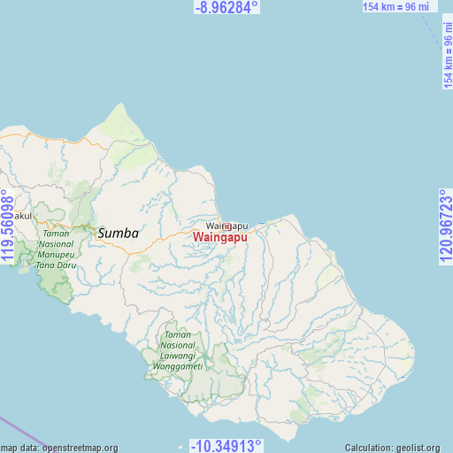
Waingapu GPS coordinates[2]
9° 39' 24.12" South, 120° 15' 50.76" East
| Map corner | latitude | longitude |
|---|---|---|
| Upper-left | -8.96284°, | 119.56098° |
| Center: | -9.6567°, | 120.2641° |
| Lower-right: | -10.34913°, | 120.96723° |
| Map W x H: | 154.1×154.1 km | = 95.8×95.8mi |
| max Lat: | 5.88969° ⇑94.3% North |
| Waingapu: | -9.6567° |
| min Lat: | ⇓5.7% South -10.934° |
| min Long | Waingapu | max Long |
| 95.1345° | 120.2641° | 140.9419° |
| W 83.5%⇐ | ⇒16.5% E |
Elevation
Elevation of Waingapu is 26 m = 85 ft, and this is 203.7 m = 668 ft below average elevation for this country.
| Max E: |
3185 m = 10449 ft | 74.1% |
| Avg. | 229.7 m = 754 ft | |
| Waingapu | 26 m = 85 ft | |
Min E: |
-1 m = -3 ft | 25.9% |
See also: Waingapu elevation on elevation.city.
Geographical zone
Waingapu is located in South Torrid zone (between Equator and Tropic of Capricorn). Distance of Equator is 1073.7 km =667.2 mi to North.| Distance of | km | miles | from Waingapu |
|---|---|---|---|
| Equator | 1073.7 | 667.2 | to North |
| Tropic Capricorn | 1532.2 | 952.1 | to South |
| Antarctic Circle | 6327.4 | 3931.7 | to South |
| South Pole | 8933.3 | 5550.9 | to South |


Nearby cities:
15 places around Waingapu: (largest is in red/bold)
• Apuhambati
8.7 km =5.4 mi,  211°
211°
• Kabandang
9.9 km =6.2 mi,  188°
188°
• Kamalaputi
0.9 km =0.6 mi,  355°
355°
• Karara
2.6 km =1.6 mi,  288°
288°
• Kawangu
8.6 km =5.3 mi,  102°
102°
• Kawangu Satu
7.4 km =4.6 mi,  108°
108°
• Landa
8.4 km =5.2 mi,  328°
328°
• Mangga Dua
3.2 km =2 mi, 101°
• Palindi
9 km =5.6 mi,  131°
131°
• Penang
21 km =13 mi, 185°
• Tambulatana
17.6 km =10.9 mi,  335°
335°
• Tanabara
4.8 km =3 mi,  141°
141°
• Tanahwurung
4.3 km =2.7 mi,  162°
162°
• Umburarameha
2.2 km =1.4 mi,  249°
249°
• Wairinding
14.8 km =9.2 mi,  262°
262°
Sources, notices
• [Note1] Compared only with cities in Indonesia existing in our database
• [Src1] Map data: © OpenStreetMap contributors (CC-BY-SA)
• [Src2] Other city data from geonames.org with taken over terms of usage.
• [Src3] Geographical zone / Annual Mean Temperature by Robert A. Rohde @ Wikipedia
