Tumpang geodata
Tumpang (East Java) is a seat of a third-order administrative division; located in Indonesia in Asia/Jakarta (GMT+7) time zone. In our database, there are 407 cities with bigger population. Compared to other cities in Indonesia, 61.5% of cities are located further ↑North; 57.5% of cities are located further ←West and 89.2% of cities have lower elevation than Tumpang. Note1


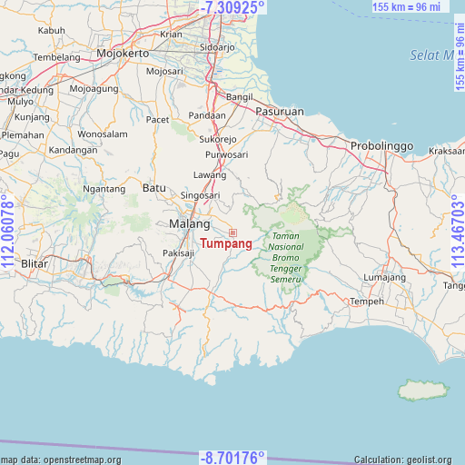
Tumpang GPS coordinates[2]
8° 0' 21.96" South, 112° 45' 50.04" East
| Map corner | latitude | longitude |
|---|---|---|
| Upper-left | -7.30925°, | 112.06078° |
| Center: | -8.0061°, | 112.7639° |
| Lower-right: | -8.70176°, | 113.46703° |
| Map W x H: | 154.8×154.8 km | = 96.2×96.2mi |
| max Lat: | 5.88969° ⇑61.5% North |
| Tumpang: | -8.0061° |
| min Lat: | ⇓38.5% South -10.934° |
| min Long | Tumpang | max Long |
| 95.1345° | 112.7639° | 140.9419° |
| W 57.5%⇐ | ⇒42.5% E |
Elevation
Elevation of Tumpang is 614 m = 2014 ft, and this is 384.3 m = 1261 ft above average elevation for this country.
| Max E: |
3185 m = 10449 ft | 10.8% |
| Tumpang | 614 m 2014 ft | |
| Avg. | 229.7 m = 754 ft | |
Min E: |
-1 m = -3 ft | 89.2% |
See also: Indonesia elevation on elevation.city.
Geographical zone
Tumpang is located in South Torrid zone (between Equator and Tropic of Capricorn). Distance of Equator is 890.2 km =553.1 mi to North.| Distance of | km | miles | from Tumpang |
|---|---|---|---|
| Equator | 890.2 | 553.1 | to North |
| Tropic Capricorn | 1715.7 | 1066.1 | to South |
| Antarctic Circle | 6511 | 4045.7 | to South |
| South Pole | 9116.9 | 5665 | to South |


Nearby cities:
15 places around Tumpang: (largest is in red/bold)
• Belung Satu
3.1 km =1.9 mi,  169°
169°
• Bokor
2.5 km =1.6 mi,  273°
273°
• Glagahdowo
3.4 km =2.1 mi,  247°
247°
• Kambingan
5.9 km =3.7 mi,  263°
263°
• Kedampul
5.4 km =3.4 mi,  94°
94°
• Keden
4 km =2.5 mi,  217°
217°
• Krajan
1 km =0.6 mi,  140°
140°
• Ngebruk
5.4 km =3.4 mi,  213°
213°
• Ngingit
5.8 km =3.6 mi,  243°
243°
• Nongkosewu
4.4 km =2.7 mi,  179°
179°
• Simpanganduwet
4.7 km =2.9 mi,  128°
128°
• Tamiajeng
4.9 km =3 mi, 268°
• Tumpang Satu
0.3 km =0.2 mi, 265°
• Wates
3.9 km =2.4 mi, 173°
• Wonorejo
4.8 km =3 mi,  156°
156°
Sources, notices
• [Note1] Compared only with cities in Indonesia existing in our database
• [Src1] Map data: © OpenStreetMap contributors (CC-BY-SA)
• [Src2] Other city data from geonames.org with taken over terms of usage.
• [Src3] Geographical zone / Annual Mean Temperature by Robert A. Rohde @ Wikipedia
