Tombatu geodata
Tombatu (North Sulawesi) is a seat of a third-order administrative division; located in Indonesia in Asia/Makassar (GMT+8) time zone. In our database, there are 407 cities with bigger population. Compared to other cities in Indonesia, 96.2% of cities are located further ↓South; 97.5% of cities are located further ←West and 77.4% of cities have lower elevation than Tombatu. Note1


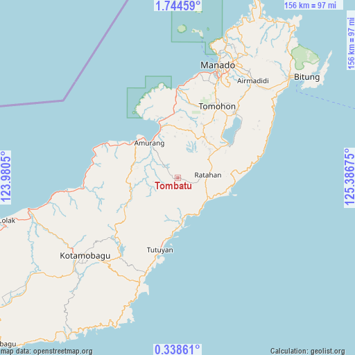
Tombatu GPS coordinates[2]
1° 2' 30.048" North, 124° 41' 1.032" East
| Map corner | latitude | longitude |
|---|---|---|
| Upper-left | 1.74459°, | 123.9805° |
| Center: | 1.04168°, | 124.68362° |
| Lower-right: | 0.33861°, | 125.38675° |
| Map W x H: | 156.3×156.3 km | = 97.1×97.1mi |
| max Lat: | 5.88969° ⇑3.8% North |
| Tombatu: | 1.04168° |
| min Lat: | ⇓96.2% South -10.934° |
| min Long | Tombatu | max Long |
| 95.1345° | 124.68362° | 140.9419° |
| W 97.5%⇐ | ⇒2.5% E |
Elevation
Elevation of Tombatu is 391 m = 1283 ft, and this is 161.3 m = 529 ft above average elevation for this country.
| Max E: |
3185 m = 10449 ft | 22.6% |
| Tombatu | 391 m 1283 ft | |
| Avg. | 229.7 m = 754 ft | |
Min E: |
-1 m = -3 ft | 77.4% |
See also: Indonesia elevation on elevation.city.
Geographical zone
Tombatu is located in North Torrid zone (between Equator and Tropic of Cancer). Distance of Equator is 115.8 km =72 mi to South.| Distance of | km | miles | from Tombatu |
|---|---|---|---|
| North Pole | 9891.2 | 6146.1 | to North |
| Arctic Circle | 7285.4 | 4526.9 | to North |
| Tropic Cancer | 2490.1 | 1547.3 | to North |
| Equator | 115.8 | 72 | to South |


Nearby cities:
15 places around Tombatu: (largest is in red/bold)
• Bilalang
52 km =32.3 mi,  234°
234°
• Kawangkoan
21.2 km =13.2 mi,  31°
31°
• Kotabunan
25.7 km =16 mi,  186°
186°
• Modayag
49.7 km =30.9 mi,  222°
222°
• Pineleng
45.9 km =28.5 mi,  22°
22°
• Poigar
41.7 km =25.9 mi,  266°
266°
• Poigar
44.9 km =27.9 mi,  263°
263°
• Ratahan
13.2 km =8.2 mi,  83°
83°
• Sonder
26 km =16.2 mi, 24°
• Tanahwangko
39.1 km =24.3 mi,  359°
359°
• Tenga
30.3 km =18.8 mi,  296°
296°
• Tomohon
33.4 km =20.8 mi, 23°
• Tompasobaru
27.4 km =17 mi,  240°
240°
• Tondano
38.8 km =24.1 mi,  40°
40°
• Tutuyan
31.7 km =19.7 mi, 194°
Sources, notices
• [Note1] Compared only with cities in Indonesia existing in our database
• [Src1] Map data: © OpenStreetMap contributors (CC-BY-SA)
• [Src2] Other city data from geonames.org with taken over terms of usage.
• [Src3] Geographical zone / Annual Mean Temperature by Robert A. Rohde @ Wikipedia
