Tenga geodata
Tenga (North Sulawesi) is a seat of a third-order administrative division; located in Indonesia in Asia/Makassar (GMT+8) time zone. In our database, there are 407 cities with bigger population. Compared to other cities in Indonesia, 96.4% of cities are located further ↓South; 96.1% of cities are located further ←West and 52.7% of cities have higher elevation than Tenga. Note1


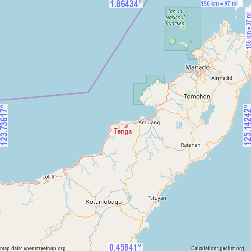
Tenga GPS coordinates[2]
1° 9' 41.256" North, 124° 26' 21.444" East
| Map corner | latitude | longitude |
|---|---|---|
| Upper-left | 1.86434°, | 123.73617° |
| Center: | 1.16146°, | 124.43929° |
| Lower-right: | 0.45841°, | 125.14242° |
| Map W x H: | 156.3×156.3 km | = 97.1×97.1mi |
| max Lat: | 5.88969° ⇑3.6% North |
| Tenga: | 1.16146° |
| min Lat: | ⇓96.4% South -10.934° |
| min Long | Tenga | max Long |
| 95.1345° | 124.43929° | 140.9419° |
| W 96.1%⇐ | ⇒3.9% E |
Elevation
Elevation of Tenga is 93 m = 305 ft, and this is 136.7 m = 448 ft below average elevation for this country.
| Max E: |
3185 m = 10449 ft | 52.7% |
| Avg. | 229.7 m = 754 ft | |
| Tenga | 93 m = 305 ft | |
Min E: |
-1 m = -3 ft | 47.3% |
See also: Indonesia elevation on elevation.city.
Geographical zone
Tenga is located in North Torrid zone (between Equator and Tropic of Cancer). Distance of Equator is 129.1 km =80.2 mi to South.| Distance of | km | miles | from Tenga |
|---|---|---|---|
| North Pole | 9877.9 | 6137.8 | to North |
| Arctic Circle | 7272 | 4518.6 | to North |
| Tropic Cancer | 2476.8 | 1539 | to North |
| Equator | 129.1 | 80.2 | to South |


Nearby cities:
15 places around Tenga: (largest is in red/bold)
• Bilalang
45.9 km =28.5 mi,  199°
199°
• Bolaang
39.9 km =24.8 mi,  232°
232°
• Kawangkoan
38.4 km =23.9 mi,  82°
82°
• Kotabunan
45.7 km =28.4 mi,  148°
148°
• Passi
46.7 km =29 mi, 199°
• Poigar
21.3 km =13.2 mi,  222°
222°
• Poigar
25.4 km =15.8 mi, 223°
• Ratahan
41.9 km =26 mi,  106°
106°
• Sonder
39.2 km =24.4 mi,  74°
74°
• Tanahwangko
37.4 km =23.2 mi,  46°
46°
• Tombatu
30.3 km =18.8 mi,  116°
116°
• Tomohon
44 km =27.3 mi, 66°
• Tompasobaru
27 km =16.8 mi,  173°
173°
• Tungoo
50.2 km =31.2 mi, 203°
• Tutuyan
48.1 km =29.9 mi,  156°
156°
Sources, notices
• [Note1] Compared only with cities in Indonesia existing in our database
• [Src1] Map data: © OpenStreetMap contributors (CC-BY-SA)
• [Src2] Other city data from geonames.org with taken over terms of usage.
• [Src3] Geographical zone / Annual Mean Temperature by Robert A. Rohde @ Wikipedia
