Tanggul geodata
Tanggul (East Java) is a seat of a third-order administrative division; located in Indonesia in Asia/Jakarta (GMT+7) time zone. With population of 3 people, there are 406 cities with bigger population in this country. Compared to other cities in Indonesia, 69.4% of cities are located further ↑North; 61.7% of cities are located further ←West and 67.4% of cities have higher elevation than Tanggul. Note1


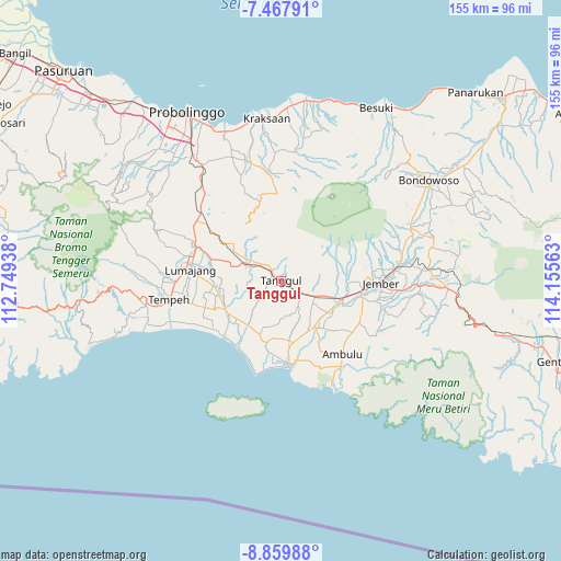
Tanggul GPS coordinates[2]
8° 9' 52.2" South, 113° 27' 9" East
| Map corner | latitude | longitude |
|---|---|---|
| Upper-left | -7.46791°, | 112.74938° |
| Center: | -8.1645°, | 113.4525° |
| Lower-right: | -8.85988°, | 114.15563° |
| Map W x H: | 154.8×154.8 km | = 96.2×96.2mi |
| max Lat: | 5.88969° ⇑69.4% North |
| Tanggul: | -8.1645° |
| min Lat: | ⇓30.6% South -10.934° |
| min Long | Tanggul | max Long |
| 95.1345° | 113.4525° | 140.9419° |
| W 61.7%⇐ | ⇒38.3% E |
Elevation
Elevation of Tanggul is 37 m = 121 ft, and this is 192.7 m = 632 ft below average elevation for this country.
| Max E: |
3185 m = 10449 ft | 67.4% |
| Avg. | 229.7 m = 754 ft | |
| Tanggul | 37 m = 121 ft | |
Min E: |
-1 m = -3 ft | 32.6% |
See also: Indonesia elevation on elevation.city.
Geographical zone
Tanggul is located in South Torrid zone (between Equator and Tropic of Capricorn). Distance of Equator is 907.8 km =564.1 mi to North.| Distance of | km | miles | from Tanggul |
|---|---|---|---|
| Equator | 907.8 | 564.1 | to North |
| Tropic Capricorn | 1698.1 | 1055.2 | to South |
| Antarctic Circle | 6493.4 | 4034.8 | to South |
| South Pole | 9099.3 | 5654 | to South |


Nearby cities:
15 places around Tanggul: (largest is in red/bold)
• Curahkalong
6.7 km =4.2 mi,  98°
98°
• Darungan
4.2 km =2.6 mi,  79°
79°
• Klatakan
4.8 km =3 mi,  123°
123°
• Kramat
3.7 km =2.3 mi,  355°
355°
• Patemon
1.4 km =0.9 mi,  4°
4°
• Pondokdalem
3.2 km =2 mi,  307°
307°
• Pringgowirawan
6.3 km =3.9 mi,  316°
316°
• Rejoagung
5.7 km =3.5 mi,  223°
223°
• Rowotengu
3 km =1.9 mi,  259°
259°
• Semboro Lor
3 km =1.9 mi,  197°
197°
• Semboropasar
5.2 km =3.2 mi,  189°
189°
• Sidomekar
5.3 km =3.3 mi,  169°
169°
• Silodakon
5.5 km =3.4 mi,  93°
93°
• Tanggul Kulon
0.5 km =0.3 mi,  267°
267°
• Tanggul Wetan
2.2 km =1.4 mi,  111°
111°
Sources, notices
• [Note1] Compared only with cities in Indonesia existing in our database
• [Src1] Map data: © OpenStreetMap contributors (CC-BY-SA)
• [Src2] Other city data from geonames.org with taken over terms of usage.
• [Src3] Geographical zone / Annual Mean Temperature by Robert A. Rohde @ Wikipedia
