Sumenep geodata
Sumenep (East Java) is a seat of a second-order administrative division; located in Indonesia in Asia/Jakarta (GMT+7) time zone. With population of 84,656 people, there are 154 cities with bigger population in this country. Compared to other cities in Indonesia, 64.8% of cities are located further ↓South; 66.2% of cities are located further ←West and 99.1% of cities have higher elevation than Sumenep. Note1


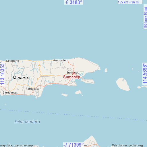
Sumenep GPS coordinates[2]
7° 1' 0.012" South, 113° 52' 0.012" East
| Map corner | latitude | longitude |
|---|---|---|
| Upper-left | -6.3183°, | 113.16355° |
| Center: | -7.01667°, | 113.86667° |
| Lower-right: | -7.71399°, | 114.5698° |
| Map W x H: | 155.2×155.2 km | = 96.4×96.4mi |
| max Lat: | 5.88969° ⇑35.2% North |
| Sumenep: | -7.01667° |
| min Lat: | ⇓64.8% South -10.934° |
| min Long | Sumenep | max Long |
| 95.1345° | 113.86667° | 140.9419° |
| W 66.2%⇐ | ⇒33.8% E |
Elevation
Elevation of Sumenep is 4 m = 13 ft, and this is 225.7 m = 740 ft below average elevation for this country.
| Max E: |
3185 m = 10449 ft | 99.1% |
| Avg. | 229.7 m = 754 ft | |
| Sumenep | 4 m = 13 ft | |
Min E: |
-1 m = -3 ft | 0.9% |
See also: Sumenep elevation on elevation.city.
Geographical zone
Sumenep is located in South Torrid zone (between Equator and Tropic of Capricorn). Distance of Equator is 780.2 km =484.8 mi to North.| Distance of | km | miles | from Sumenep |
|---|---|---|---|
| Equator | 780.2 | 484.8 | to North |
| Tropic Capricorn | 1825.7 | 1134.4 | to South |
| Antarctic Circle | 6621 | 4114.1 | to South |
| South Pole | 9226.9 | 5733.3 | to South |


Nearby cities:
15 places around Sumenep: (largest is in red/bold)
• Batujaran
4.8 km =3 mi,  57°
57°
• Bereklorong
4.9 km =3 mi,  114°
114°
• Cemara
3.8 km =2.4 mi,  123°
123°
• Ganjur
4.1 km =2.5 mi,  349°
349°
• Giring Barat
5.5 km =3.4 mi,  1°
1°
• Mandala
3.5 km =2.2 mi,  15°
15°
• Masjid
4 km =2.5 mi,  127°
127°
• Padusan
2 km =1.2 mi,  28°
28°
• Palebunan
4.6 km =2.9 mi,  163°
163°
• Pandaringan Barat
3.3 km =2.1 mi,  53°
53°
• Pasarkayu
2.1 km =1.3 mi, 123°
• Patenongan
2.4 km =1.5 mi,  42°
42°
• Penatu
4.3 km =2.7 mi, 123°
• Senmasen
3.1 km =1.9 mi,  356°
356°
• Talbantal
1.7 km =1.1 mi, 55°
Sources, notices
• [Note1] Compared only with cities in Indonesia existing in our database
• [Src1] Map data: © OpenStreetMap contributors (CC-BY-SA)
• [Src2] Other city data from geonames.org with taken over terms of usage.
• [Src3] Geographical zone / Annual Mean Temperature by Robert A. Rohde @ Wikipedia
