Sampalan geodata
Sampalan (Bali) is a seat of a third-order administrative division; located in Indonesia in Asia/Makassar (GMT+8) time zone. In our database, there are 407 cities with bigger population. Compared to other cities in Indonesia, 88.7% of cities are located further ↑North; 75.2% of cities are located further ←West and 93.7% of cities have higher elevation than Sampalan. Note1


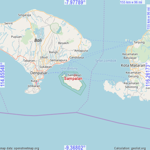
Sampalan GPS coordinates[2]
8° 40' 24.96" South, 115° 33' 30.96" East
| Map corner | latitude | longitude |
|---|---|---|
| Upper-left | -7.97789°, | 114.85548° |
| Center: | -8.6736°, | 115.5586° |
| Lower-right: | -9.36802°, | 116.26173° |
| Map W x H: | 154.6×154.6 km | = 96.1×96.1mi |
| max Lat: | 5.88969° ⇑88.7% North |
| Sampalan: | -8.6736° |
| min Lat: | ⇓11.3% South -10.934° |
| min Long | Sampalan | max Long |
| 95.1345° | 115.5586° | 140.9419° |
| W 75.2%⇐ | ⇒24.8% E |
Elevation
Elevation of Sampalan is 8 m = 26 ft, and this is 221.7 m = 727 ft below average elevation for this country.
| Max E: |
3185 m = 10449 ft | 93.7% |
| Avg. | 229.7 m = 754 ft | |
| Sampalan | 8 m = 26 ft | |
Min E: |
-1 m = -3 ft | 6.3% |
See also: Indonesia elevation on elevation.city.
Geographical zone
Sampalan is located in South Torrid zone (between Equator and Tropic of Capricorn). Distance of Equator is 964.4 km =599.3 mi to North.| Distance of | km | miles | from Sampalan |
|---|---|---|---|
| Equator | 964.4 | 599.3 | to North |
| Tropic Capricorn | 1641.5 | 1020 | to South |
| Antarctic Circle | 6436.8 | 3999.6 | to South |
| South Pole | 9042.6 | 5618.8 | to South |


Nearby cities:
15 places around Sampalan: (largest is in red/bold)
• Batumadeg Kaja
9.9 km =6.2 mi,  215°
215°
• Gelagah
3.7 km =2.3 mi,  178°
178°
• Jungutbatu Kaja Dua
12.2 km =7.6 mi,  268°
268°
• Klumbu
6.3 km =3.9 mi, 217°
• Kutampi
0.7 km =0.4 mi,  264°
264°
• Lembongan Kawan
13.2 km =8.2 mi, 261°
• Ped
5.7 km =3.5 mi, 269°
• Pejukutan
8.9 km =5.5 mi,  160°
160°
• Pondokkaha Kelod
9.9 km =6.2 mi,  225°
225°
• Sakti
9.1 km =5.7 mi,  246°
246°
• Sekartaji
14.2 km =8.8 mi, 175°
• Suana
7.5 km =4.7 mi,  144°
144°
• Tanglad
11.5 km =7.1 mi,  166°
166°
• Tanjung
9.7 km =6 mi,  196°
196°
• Toyapakeh
7.8 km =4.8 mi, 263°
Sources, notices
• [Note1] Compared only with cities in Indonesia existing in our database
• [Src1] Map data: © OpenStreetMap contributors (CC-BY-SA)
• [Src2] Other city data from geonames.org with taken over terms of usage.
• [Src3] Geographical zone / Annual Mean Temperature by Robert A. Rohde @ Wikipedia
