Batumadeg Kaja geodata
Batumadeg Kaja (Bali) is a seat of a fourth-order administrative division; located in Indonesia in Asia/Makassar (GMT+8) time zone. In our database, there are 407 cities with bigger population. Compared to other cities in Indonesia, 90.4% of cities are located further ↑North; 75% of cities are located further ←West and 68.1% of cities have lower elevation than Batumadeg Kaja. Note1


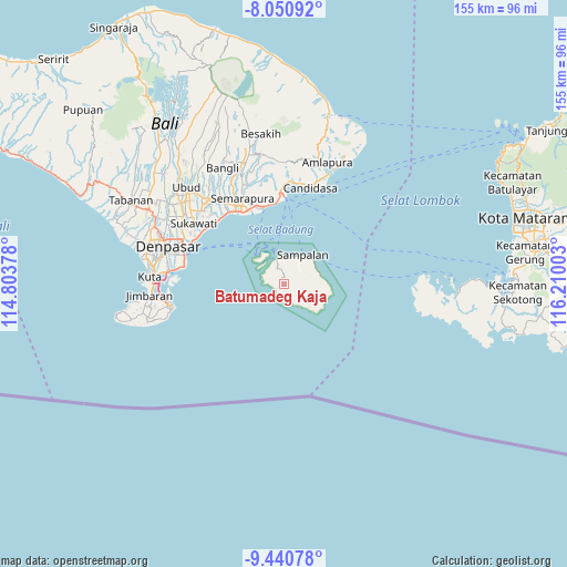
Batumadeg Kaja GPS coordinates[2]
8° 44' 47.4" South, 115° 30' 24.84" East
| Map corner | latitude | longitude |
|---|---|---|
| Upper-left | -8.05092°, | 114.80378° |
| Center: | -8.7465°, | 115.5069° |
| Lower-right: | -9.44078°, | 116.21003° |
| Map W x H: | 154.5×154.5 km | = 96×96mi |
| max Lat: | 5.88969° ⇑90.4% North |
| Batumadeg Kaja: | -8.7465° |
| min Lat: | ⇓9.6% South -10.934° |
| min Long | Batumadeg Kaja | max Long |
| 95.1345° | 115.5069° | 140.9419° |
| W 75%⇐ | ⇒25% E |
Elevation
Elevation of Batumadeg Kaja is 263 m = 863 ft, and this is 33.3 m = 109 ft above average elevation for this country.
| Max E: |
3185 m = 10449 ft | 31.9% |
| Batumadeg Kaja | 263 m 863 ft | |
| Avg. | 229.7 m = 754 ft | |
Min E: |
-1 m = -3 ft | 68.1% |
See also: Indonesia elevation on elevation.city.
Geographical zone
Batumadeg Kaja is located in South Torrid zone (between Equator and Tropic of Capricorn). Distance of Equator is 972.5 km =604.3 mi to North.| Distance of | km | miles | from Batumadeg Kaja |
|---|---|---|---|
| Equator | 972.5 | 604.3 | to North |
| Tropic Capricorn | 1633.4 | 1014.9 | to South |
| Antarctic Circle | 6428.7 | 3994.6 | to South |
| South Pole | 9034.5 | 5613.8 | to South |


Nearby cities:
15 places around Batumadeg Kaja: (largest is in red/bold)
• Gelagah
7.2 km =4.5 mi,  52°
52°
• Jungutbatu Kaja Dua
10.1 km =6.3 mi,  320°
320°
• Klumbu
3.6 km =2.2 mi,  29°
29°
• Kutampi
9.5 km =5.9 mi, 31°
• Lembongan Kawan
9.7 km =6 mi,  310°
310°
• Ped
8.1 km =5 mi,  359°
359°
• Pejukutan
8.7 km =5.4 mi,  92°
92°
• Pondokkaha Kelod
1.8 km =1.1 mi, 310°
• Sakti
5.3 km =3.3 mi,  328°
328°
• Sampalan
9.9 km =6.2 mi,  35°
35°
• Sekartaji
9.1 km =5.7 mi,  131°
131°
• Suana
10.3 km =6.4 mi,  78°
78°
• Tanglad
8.9 km =5.5 mi,  109°
109°
• Tanjung
3.2 km =2 mi, 112°
• Toyapakeh
7.5 km =4.7 mi,  343°
343°
Sources, notices
• [Note1] Compared only with cities in Indonesia existing in our database
• [Src1] Map data: © OpenStreetMap contributors (CC-BY-SA)
• [Src2] Other city data from geonames.org with taken over terms of usage.
• [Src3] Geographical zone / Annual Mean Temperature by Robert A. Rohde @ Wikipedia
