Sebewe geodata
Sebewe (West Nusa Tenggara) is a seat of a fourth-order administrative division; located in Indonesia in Asia/Makassar (GMT+8) time zone. In our database, there are 407 cities with bigger population. Compared to other cities in Indonesia, 82.7% of cities are located further ↑North; 79.1% of cities are located further ←West and 86.4% of cities have higher elevation than Sebewe. Note1


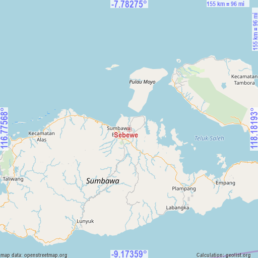
Sebewe GPS coordinates[2]
8° 28' 43.68" South, 117° 28' 43.68" East
| Map corner | latitude | longitude |
|---|---|---|
| Upper-left | -7.78275°, | 116.77568° |
| Center: | -8.4788°, | 117.4788° |
| Lower-right: | -9.17359°, | 118.18193° |
| Map W x H: | 154.6×154.7 km | = 96.1×96.1mi |
| max Lat: | 5.88969° ⇑82.7% North |
| Sebewe: | -8.4788° |
| min Lat: | ⇓17.3% South -10.934° |
| min Long | Sebewe | max Long |
| 95.1345° | 117.4788° | 140.9419° |
| W 79.1%⇐ | ⇒20.9% E |
Elevation
Elevation of Sebewe is 13 m = 43 ft, and this is 216.7 m = 711 ft below average elevation for this country.
| Max E: |
3185 m = 10449 ft | 86.4% |
| Avg. | 229.7 m = 754 ft | |
| Sebewe | 13 m = 43 ft | |
Min E: |
-1 m = -3 ft | 13.6% |
See also: Indonesia elevation on elevation.city.
Geographical zone
Sebewe is located in South Torrid zone (between Equator and Tropic of Capricorn). Distance of Equator is 942.8 km =585.8 mi to North.| Distance of | km | miles | from Sebewe |
|---|---|---|---|
| Equator | 942.8 | 585.8 | to North |
| Tropic Capricorn | 1663.2 | 1033.5 | to South |
| Antarctic Circle | 6458.4 | 4013.1 | to South |
| South Pole | 9064.3 | 5632.3 | to South |


Nearby cities:
15 places around Sebewe: (largest is in red/bold)
• Karangbalong
6.1 km =3.8 mi,  258°
258°
• Karangbugis
6.6 km =4.1 mi,  252°
252°
• Karangdima
9.6 km =6 mi,  272°
272°
• Kelungkung
17.6 km =10.9 mi,  242°
242°
• Kembansari
7.6 km =4.7 mi, 268°
• Labuhanbadas
12.3 km =7.6 mi,  277°
277°
• Labuhansumbawa
8.5 km =5.3 mi, 274°
• Lopokloka
16.2 km =10.1 mi,  152°
152°
• Ngeru
5.9 km =3.7 mi,  136°
136°
• Osapsio
7.2 km =4.5 mi, 270°
• Penyaring Bawah
1.7 km =1.1 mi,  305°
305°
• Poto
2.2 km =1.4 mi,  180°
180°
• Pototano
7.4 km =4.6 mi,  1°
1°
• Songkar B
2.2 km =1.4 mi,  108°
108°
• Sumbawa Besar
6.6 km =4.1 mi, 256°
Sources, notices
• [Note1] Compared only with cities in Indonesia existing in our database
• [Src1] Map data: © OpenStreetMap contributors (CC-BY-SA)
• [Src2] Other city data from geonames.org with taken over terms of usage.
• [Src3] Geographical zone / Annual Mean Temperature by Robert A. Rohde @ Wikipedia
