Rangkasbitung geodata
Rangkasbitung (Banten) is a seat of a second-order administrative division; located in Indonesia in Asia/Jakarta (GMT+7) time zone. With population of 126,910 people, there are 97 cities with bigger population in this country. Compared to other cities in Indonesia, 86% of cities are located further ↓South; 88.6% of cities are located further →East and 73.4% of cities have higher elevation than Rangkasbitung. Note1


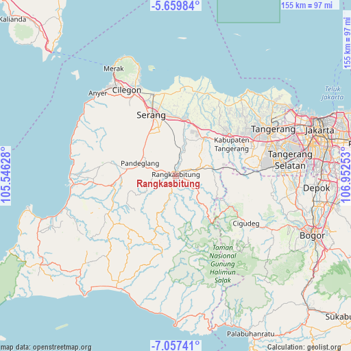
Rangkasbitung GPS coordinates[2]
6° 21' 32.76" South, 106° 14' 57.84" East
| Map corner | latitude | longitude |
|---|---|---|
| Upper-left | -5.65984°, | 105.54628° |
| Center: | -6.3591°, | 106.2494° |
| Lower-right: | -7.05741°, | 106.95253° |
| Map W x H: | 155.4×155.4 km | = 96.6×96.6mi |
| max Lat: | 5.88969° ⇑14% North |
| Rangkasbitung: | -6.3591° |
| min Lat: | ⇓86% South -10.934° |
| min Long | Rangkasbitung | max Long |
| 95.1345° | 106.2494° | 140.9419° |
| W 11.4%⇐ | ⇒88.6% E |
Elevation
Elevation of Rangkasbitung is 27 m = 89 ft, and this is 202.7 m = 665 ft below average elevation for this country.
| Max E: |
3185 m = 10449 ft | 73.4% |
| Avg. | 229.7 m = 754 ft | |
| Rangkasbitung | 27 m = 89 ft | |
Min E: |
-1 m = -3 ft | 26.6% |
See also: Rangkasbitung elevation on elevation.city.
Geographical zone
Rangkasbitung is located in South Torrid zone (between Equator and Tropic of Capricorn). Distance of Equator is 707.1 km =439.4 mi to North.| Distance of | km | miles | from Rangkasbitung |
|---|---|---|---|
| Equator | 707.1 | 439.4 | to North |
| Tropic Capricorn | 1898.9 | 1179.9 | to South |
| Antarctic Circle | 6694.1 | 4159.5 | to South |
| South Pole | 9300 | 5778.8 | to South |


Nearby cities:
15 places around Rangkasbitung: (largest is in red/bold)
• Babakankasilun
15.7 km =9.8 mi,  189°
189°
• Cibeureum Satu
16.7 km =10.4 mi,  253°
253°
• Cibogo
14.4 km =8.9 mi,  261°
261°
• Citalahab
16.4 km =10.2 mi, 263°
• Garawati
14.4 km =8.9 mi,  268°
268°
• Kabayancitiis
16.3 km =10.1 mi,  288°
288°
• Kaburon
15.7 km =9.8 mi,  300°
300°
• Kadomas
15.7 km =9.8 mi,  282°
282°
• Kadubincarung
15.6 km =9.7 mi, 272°
• Kadugedong
16.5 km =10.3 mi, 268°
• Kadumantung
16.4 km =10.2 mi, 297°
• Karangtanjung
15.5 km =9.6 mi, 300°
• Pandeglang
16.7 km =10.4 mi, 289°
• Sumurlebu Barat
16.4 km =10.2 mi, 255°
• Talagasari
16.1 km =10 mi,  199°
199°
Sources, notices
• [Note1] Compared only with cities in Indonesia existing in our database
• [Src1] Map data: © OpenStreetMap contributors (CC-BY-SA)
• [Src2] Other city data from geonames.org with taken over terms of usage.
• [Src3] Geographical zone / Annual Mean Temperature by Robert A. Rohde @ Wikipedia
