Pandeglang geodata
Pandeglang (Banten) is a seat of a second-order administrative division; located in Indonesia in Asia/Jakarta (GMT+7) time zone. With population of 92,316 people, there are 142 cities with bigger population in this country. Compared to other cities in Indonesia, 86.8% of cities are located further ↓South; 89.4% of cities are located further →East and 67.1% of cities have lower elevation than Pandeglang. Note1


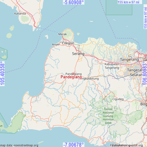
Pandeglang GPS coordinates[2]
6° 18' 30.24" South, 106° 6' 24.12" East
| Map corner | latitude | longitude |
|---|---|---|
| Upper-left | -5.60908°, | 105.40358° |
| Center: | -6.3084°, | 106.1067° |
| Lower-right: | -7.00678°, | 106.80983° |
| Map W x H: | 155.4×155.4 km | = 96.6×96.6mi |
| max Lat: | 5.88969° ⇑13.2% North |
| Pandeglang: | -6.3084° |
| min Lat: | ⇓86.8% South -10.934° |
| min Long | Pandeglang | max Long |
| 95.1345° | 106.1067° | 140.9419° |
| W 10.6%⇐ | ⇒89.4% E |
Elevation
Elevation of Pandeglang is 253 m = 830 ft, and this is 23.3 m = 76 ft above average elevation for this country.
| Max E: |
3185 m = 10449 ft | 32.9% |
| Pandeglang | 253 m 830 ft | |
| Avg. | 229.7 m = 754 ft | |
Min E: |
-1 m = -3 ft | 67.1% |
See also: Pandeglang elevation on elevation.city.
Geographical zone
Pandeglang is located in South Torrid zone (between Equator and Tropic of Capricorn). Distance of Equator is 701.4 km =435.8 mi to North.| Distance of | km | miles | from Pandeglang |
|---|---|---|---|
| Equator | 701.4 | 435.8 | to North |
| Tropic Capricorn | 1904.5 | 1183.4 | to South |
| Antarctic Circle | 6699.7 | 4163 | to South |
| South Pole | 9305.6 | 5782.2 | to South |


Nearby cities:
15 places around Pandeglang: (largest is in red/bold)
• Campraksanta
3.3 km =2.1 mi,  282°
282°
• Ciekek
1.5 km =0.9 mi,  210°
210°
• Cilaja
1.8 km =1.1 mi,  254°
254°
• Cipacung Landeuh
3.5 km =2.2 mi,  229°
229°
• Gardutanjak
0.8 km =0.5 mi, 227°
• Juhut
1.4 km =0.9 mi,  358°
358°
• Kabayancitiis
0.5 km =0.3 mi,  137°
137°
• Kaburon
3.2 km =2 mi,  43°
43°
• Kadomas
2.4 km =1.5 mi,  170°
170°
• Kadumantung
2.4 km =1.5 mi,  32°
32°
• Karangtanjung
3.2 km =2 mi,  47°
47°
• Keboncau
0.3 km =0.2 mi,  315°
315°
• Majamasjid
2.7 km =1.7 mi, 213°
• Penikebon
4.3 km =2.7 mi, 209°
• Sindanghayu
4.5 km =2.8 mi, 357°
Sources, notices
• [Note1] Compared only with cities in Indonesia existing in our database
• [Src1] Map data: © OpenStreetMap contributors (CC-BY-SA)
• [Src2] Other city data from geonames.org with taken over terms of usage.
• [Src3] Geographical zone / Annual Mean Temperature by Robert A. Rohde @ Wikipedia
