Probolinggo geodata
Probolinggo (East Java) is a populated place; located in Indonesia in Asia/Jakarta (GMT+7) time zone. With population of 181,656 people, there are 62 cities with bigger population in this country. Compared to other cities in Indonesia, 60.4% of cities are located further ↑North; 60.2% of cities are located further ←West and 84.2% of cities have higher elevation than Probolinggo. Note1


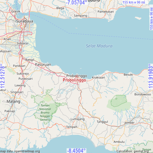
Probolinggo GPS coordinates[2]
7° 45' 15.48" South, 113° 12' 57.24" East
| Map corner | latitude | longitude |
|---|---|---|
| Upper-left | -7.05704°, | 112.51278° |
| Center: | -7.7543°, | 113.2159° |
| Lower-right: | -8.4504°, | 113.91903° |
| Map W x H: | 154.9×154.9 km | = 96.3×96.3mi |
| max Lat: | 5.88969° ⇑60.4% North |
| Probolinggo: | -7.7543° |
| min Lat: | ⇓39.6% South -10.934° |
| min Long | Probolinggo | max Long |
| 95.1345° | 113.2159° | 140.9419° |
| W 60.2%⇐ | ⇒39.8% E |
Elevation
Elevation of Probolinggo is 15 m = 49 ft, and this is 214.7 m = 704 ft below average elevation for this country.
| Max E: |
3185 m = 10449 ft | 84.2% |
| Avg. | 229.7 m = 754 ft | |
| Probolinggo | 15 m = 49 ft | |
Min E: |
-1 m = -3 ft | 15.8% |
See also: Probolinggo elevation on elevation.city.
Geographical zone
Probolinggo is located in South Torrid zone (between Equator and Tropic of Capricorn). Distance of Equator is 862.2 km =535.7 mi to North.| Distance of | km | miles | from Probolinggo |
|---|---|---|---|
| Equator | 862.2 | 535.7 | to North |
| Tropic Capricorn | 1743.7 | 1083.5 | to South |
| Antarctic Circle | 6539 | 4063.1 | to South |
| South Pole | 9144.9 | 5682.4 | to South |


Nearby cities:
15 places around Probolinggo: (largest is in red/bold)
• Antrukan
28.3 km =17.6 mi,  184°
184°
• Bringinanom
26.2 km =16.3 mi,  87°
87°
• Jabung Wetan
29.9 km =18.6 mi, 87°
• Jabungsisir
28 km =17.4 mi,  84°
84°
• Kalibuntu
22.2 km =13.8 mi, 84°
• Krajan Dua
30.3 km =18.8 mi,  172°
172°
• Krajan Jabungcandi
29.3 km =18.2 mi, 85°
• Krajan Kebonagung
25.6 km =15.9 mi, 88°
• Kraksaan
19.9 km =12.4 mi, 91°
• Makam
27.7 km =17.2 mi, 180°
• Parseh
27 km =16.8 mi, 88°
• Randumerak
29.4 km =18.3 mi, 84°
• Sidorejo
28.7 km =17.8 mi,  187°
187°
• Srunikrajan
27.7 km =17.2 mi, 175°
• Taman
29.5 km =18.3 mi, 179°
Sources, notices
• [Note1] Compared only with cities in Indonesia existing in our database
• [Src1] Map data: © OpenStreetMap contributors (CC-BY-SA)
• [Src2] Other city data from geonames.org with taken over terms of usage.
• [Src3] Geographical zone / Annual Mean Temperature by Robert A. Rohde @ Wikipedia
