Kraksaan geodata
Kraksaan (East Java) is a populated place; located in Indonesia in Asia/Jakarta (GMT+7) time zone. With population of 28,248 people, there are 327 cities with bigger population in this country. Compared to other cities in Indonesia, 60.5% of cities are located further ↑North; 61.3% of cities are located further ←West and 99.8% of cities have higher elevation than Kraksaan. Note1


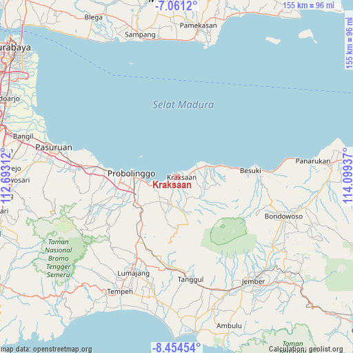
Kraksaan GPS coordinates[2]
7° 45' 30.42" South, 113° 23' 46.464" East
| Map corner | latitude | longitude |
|---|---|---|
| Upper-left | -7.0612°, | 112.69312° |
| Center: | -7.75845°, | 113.39624° |
| Lower-right: | -8.45454°, | 114.09937° |
| Map W x H: | 154.9×154.9 km | = 96.3×96.3mi |
| max Lat: | 5.88969° ⇑60.5% North |
| Kraksaan: | -7.75845° |
| min Lat: | ⇓39.5% South -10.934° |
| min Long | Kraksaan | max Long |
| 95.1345° | 113.39624° | 140.9419° |
| W 61.3%⇐ | ⇒38.7% E |
Elevation
Elevation of Kraksaan is 1 m = 3 ft, and this is 228.7 m = 750 ft below average elevation for this country.
| Max E: |
3185 m = 10449 ft | 99.8% |
| Avg. | 229.7 m = 754 ft | |
| Kraksaan | 1 m = 3 ft | |
Min E: |
-1 m = -3 ft | 0.2% |
See also: Indonesia elevation on elevation.city.
Geographical zone
Kraksaan is located in South Torrid zone (between Equator and Tropic of Capricorn). Distance of Equator is 862.7 km =536.1 mi to North.| Distance of | km | miles | from Kraksaan |
|---|---|---|---|
| Equator | 862.7 | 536.1 | to North |
| Tropic Capricorn | 1743.3 | 1083.2 | to South |
| Antarctic Circle | 6538.5 | 4062.8 | to South |
| South Pole | 9144.4 | 5682.1 | to South |


Nearby cities:
15 places around Kraksaan: (largest is in red/bold)
• Bringinanom
6.6 km =4.1 mi,  74°
74°
• Jabung Wetan
10.2 km =6.3 mi,  79°
79°
• Jabungsisir
8.6 km =5.3 mi, 69°
• Jambesari
28.7 km =17.8 mi,  182°
182°
• Kalibuntu
3.4 km =2.1 mi,  42°
42°
• Krajan Alastengah
11 km =6.8 mi, 84°
• Krajan Jabungcandi
9.8 km =6.1 mi, 73°
• Krajan Kebonagung
5.9 km =3.7 mi, 78°
• Kramat
12.1 km =7.5 mi,  57°
57°
• Parseh
7.2 km =4.5 mi, 81°
• Probolinggo
19.9 km =12.4 mi,  271°
271°
• Randumerak
10 km =6.2 mi, 69°
• Sidodadi
11.1 km =6.9 mi, 78°
• Srunikrajan
32.5 km =20.2 mi,  213°
213°
• Tanjung Kidul
12 km =7.5 mi, 69°
Sources, notices
• [Note1] Compared only with cities in Indonesia existing in our database
• [Src1] Map data: © OpenStreetMap contributors (CC-BY-SA)
• [Src2] Other city data from geonames.org with taken over terms of usage.
• [Src3] Geographical zone / Annual Mean Temperature by Robert A. Rohde @ Wikipedia
