Pasauran geodata
Pasauran (Banten) is a seat of a fourth-order administrative division; located in Indonesia in Asia/Jakarta (GMT+7) time zone. In our database, there are 407 cities with bigger population. Compared to other cities in Indonesia, 87.2% of cities are located further ↓South; 93.4% of cities are located further →East and 90.6% of cities have higher elevation than Pasauran. Note1


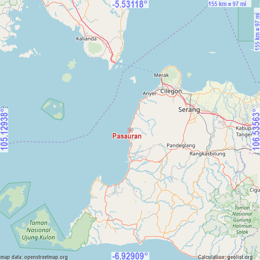
Pasauran GPS coordinates[2]
6° 13' 50.16" South, 105° 49' 57" East
| Map corner | latitude | longitude |
|---|---|---|
| Upper-left | -5.53118°, | 105.12938° |
| Center: | -6.2306°, | 105.8325° |
| Lower-right: | -6.92909°, | 106.53563° |
| Map W x H: | 155.4×155.4 km | = 96.6×96.6mi |
| max Lat: | 5.88969° ⇑12.8% North |
| Pasauran: | -6.2306° |
| min Lat: | ⇓87.2% South -10.934° |
| min Long | Pasauran | max Long |
| 95.1345° | 105.8325° | 140.9419° |
| W 6.6%⇐ | ⇒93.4% E |
Elevation
Elevation of Pasauran is 10 m = 33 ft, and this is 219.7 m = 721 ft below average elevation for this country.
| Max E: |
3185 m = 10449 ft | 90.6% |
| Avg. | 229.7 m = 754 ft | |
| Pasauran | 10 m = 33 ft | |
Min E: |
-1 m = -3 ft | 9.4% |
See also: Indonesia elevation on elevation.city.
Geographical zone
Pasauran is located in South Torrid zone (between Equator and Tropic of Capricorn). Distance of Equator is 692.8 km =430.5 mi to North.| Distance of | km | miles | from Pasauran |
|---|---|---|---|
| Equator | 692.8 | 430.5 | to North |
| Tropic Capricorn | 1913.1 | 1188.7 | to South |
| Antarctic Circle | 6708.4 | 4168.4 | to South |
| South Pole | 9314.3 | 5787.6 | to South |


Nearby cities:
15 places around Pasauran: (largest is in red/bold)
• Bantarwaru
4.7 km =2.9 mi,  48°
48°
• Bengras
1.9 km =1.2 mi,  180°
180°
• Carita
9.7 km =6 mi, 176°
• Cinoyong
6.2 km =3.9 mi,  91°
91°
• Citajur
6 km =3.7 mi,  185°
185°
• Dahu
4.9 km =3 mi,  70°
70°
• Kadumonyong
8.7 km =5.4 mi,  41°
41°
• Kasepen
9.2 km =5.7 mi,  173°
173°
• Kawoyang
3.6 km =2.2 mi,  112°
112°
• Kopibaru
8.8 km =5.5 mi,  30°
30°
• Kopibera
9.6 km =6 mi, 28°
• Pondokwaru
3.8 km =2.4 mi,  11°
11°
• Tangkil
9.6 km =6 mi, 168°
• Tawingmuara
7.8 km =4.8 mi,  18°
18°
• Umbultanjung
0.4 km =0.2 mi,  196°
196°
Sources, notices
• [Note1] Compared only with cities in Indonesia existing in our database
• [Src1] Map data: © OpenStreetMap contributors (CC-BY-SA)
• [Src2] Other city data from geonames.org with taken over terms of usage.
• [Src3] Geographical zone / Annual Mean Temperature by Robert A. Rohde @ Wikipedia
