Parungponteng geodata
Parungponteng (West Java) is a seat of a fourth-order administrative division; located in Indonesia in Asia/Jakarta (GMT+7) time zone. In our database, there are 407 cities with bigger population. Compared to other cities in Indonesia, 55.8% of cities are located further ↑North; 77.7% of cities are located further →East and 60.7% of cities have lower elevation than Parungponteng. Note1


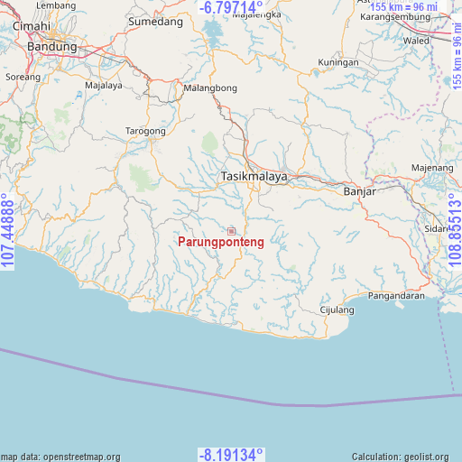
Parungponteng GPS coordinates[2]
7° 29' 41.28" South, 108° 9' 7.2" East
| Map corner | latitude | longitude |
|---|---|---|
| Upper-left | -6.79714°, | 107.44888° |
| Center: | -7.4948°, | 108.152° |
| Lower-right: | -8.19134°, | 108.85513° |
| Map W x H: | 155×155 km | = 96.3×96.3mi |
| max Lat: | 5.88969° ⇑55.8% North |
| Parungponteng: | -7.4948° |
| min Lat: | ⇓44.2% South -10.934° |
| min Long | Parungponteng | max Long |
| 95.1345° | 108.152° | 140.9419° |
| W 22.3%⇐ | ⇒77.7% E |
Elevation
Elevation of Parungponteng is 172 m = 564 ft, and this is 57.7 m = 189 ft below average elevation for this country.
| Max E: |
3185 m = 10449 ft | 39.3% |
| Avg. | 229.7 m = 754 ft | |
| Parungponteng | 172 m = 564 ft | |
Min E: |
-1 m = -3 ft | 60.7% |
See also: Indonesia elevation on elevation.city.
Geographical zone
Parungponteng is located in South Torrid zone (between Equator and Tropic of Capricorn). Distance of Equator is 833.3 km =517.8 mi to North.| Distance of | km | miles | from Parungponteng |
|---|---|---|---|
| Equator | 833.3 | 517.8 | to North |
| Tropic Capricorn | 1772.6 | 1101.4 | to South |
| Antarctic Circle | 6567.8 | 4081 | to South |
| South Pole | 9173.7 | 5700.3 | to South |


Nearby cities:
15 places around Parungponteng: (largest is in red/bold)
• Cibalong
3.9 km =2.4 mi,  124°
124°
• Cibungur
2.9 km =1.8 mi,  226°
226°
• Cigunung
4.1 km =2.5 mi,  270°
270°
• Cijoho
6.1 km =3.8 mi,  2°
2°
• Cikendi
5.3 km =3.3 mi, 119°
• Desakolot
2.9 km =1.8 mi,  288°
288°
• Januti
3.7 km =2.3 mi,  316°
316°
• Kampungbaru
0.8 km =0.5 mi,  53°
53°
• Lengkongjaya
2.2 km =1.4 mi,  157°
157°
• Nangkasari
4.5 km =2.8 mi,  142°
142°
• Pakalongan
5.4 km =3.4 mi,  296°
296°
• Parakantiga
6.1 km =3.8 mi,  44°
44°
• Pasir
4.2 km =2.6 mi,  56°
56°
• Rancamulya
4.3 km =2.7 mi,  108°
108°
• Sukasenang
4.9 km =3 mi, 110°
Sources, notices
• [Note1] Compared only with cities in Indonesia existing in our database
• [Src1] Map data: © OpenStreetMap contributors (CC-BY-SA)
• [Src2] Other city data from geonames.org with taken over terms of usage.
• [Src3] Geographical zone / Annual Mean Temperature by Robert A. Rohde @ Wikipedia
